Blog · Critical infrastructure
Biggest Airports in the Middle East: 6 Hubs, Live Data
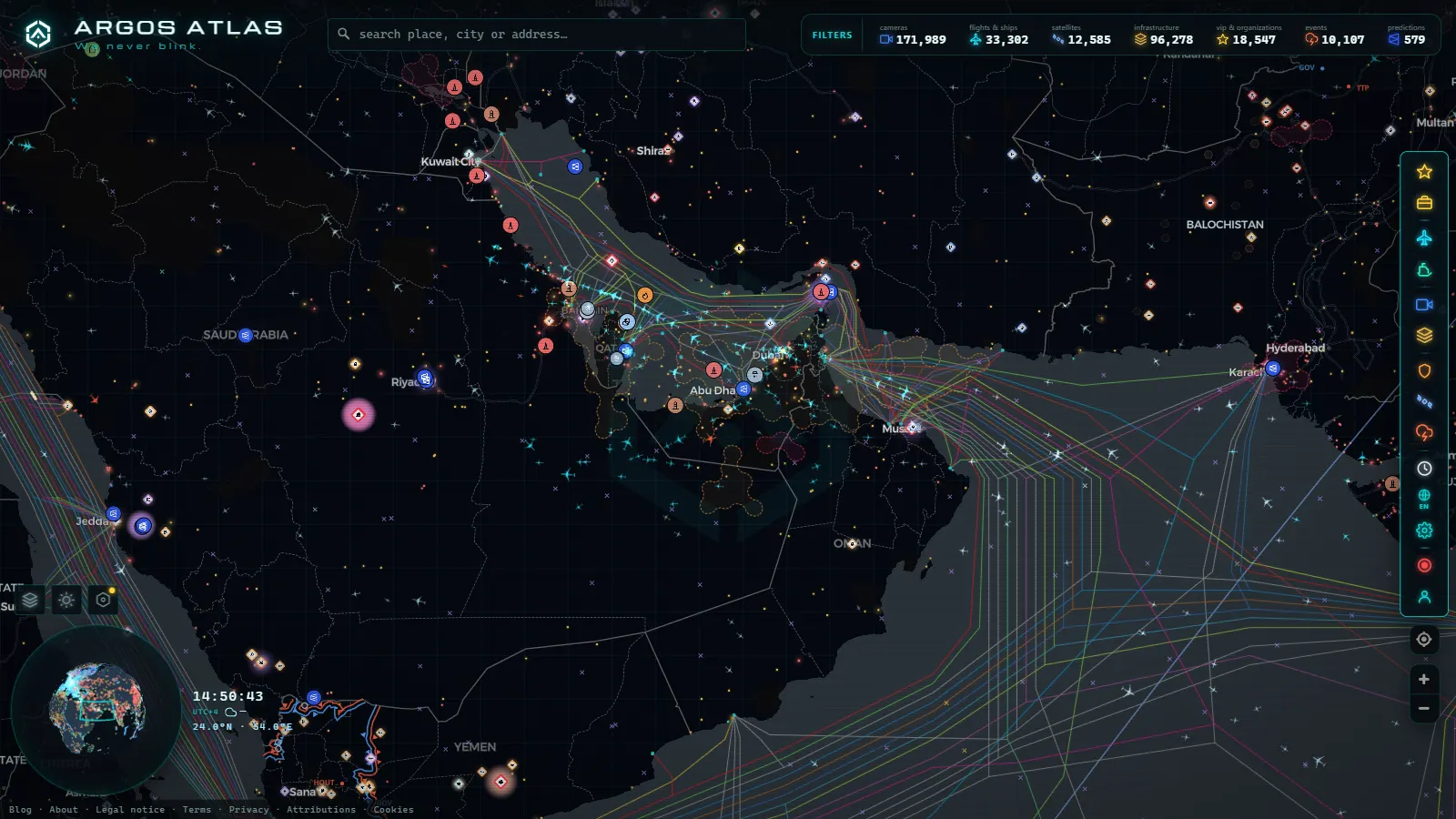
Dubai International (DXB) turns up on more long haul flight plans than almost any other airport on the planet, and the country it serves is smaller than Scotland. Doha and Abu Dhabi sit in the same position, one very large airport each and almost no domestic market to feed it. That contradiction is the whole story of the Gulf. These airports did not grow because of the people living around them. They grew because of where they sit on the globe.
What follows is a hub by hub look at the biggest airports in the Middle East, with one rule applied throughout. Every figure here is either a dated count from our own catalogue or it is not given at all. Passenger totals published by airport authorities and by the airport councils are real numbers, but they are not ours and we do not measure them, so where we do not hold a figure you get a qualitative sentence instead of an invented one. Each table column below says where it comes from.
The essentials, in 20 seconds
- Dubai International (DXB): the region's largest transfer hub, built around a single base of one very large widebody fleet.
- Hamad International (DOH): Doha's hub, the second Gulf transfer hub, built as a one airport national strategy.
- Zayed International (AUH): Abu Dhabi's hub, close enough to Dubai that both fit on one screen and often share approach airspace.
- King Abdulaziz (JED): the gateway to Mecca, the only hub on this list whose peak is religious rather than commercial.
- Istanbul (IST): normally counted with Europe, reaching more countries than any single Gulf hub.
The biggest airports in the Middle East, hub by hub
Six airports carry the bulk of the region's intercontinental traffic. Five are Gulf and Red Sea hubs. The sixth, Istanbul, is normally counted with Europe, and it belongs in both lists for exactly the reason it exists at all.
| Hub | Code | Role in the network | What the live map can show | Where the column comes from |
|---|---|---|---|---|
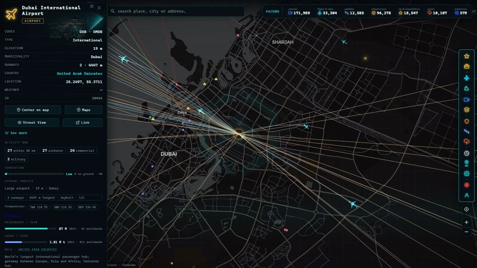
| Dubai International | DXB | The region's largest transfer hub, single base of one very large widebody fleet | Fixed airport marker, plus every aircraft overhead that is broadcasting at that moment | Marker: airport catalogue. Aircraft: live ADS-B feed |
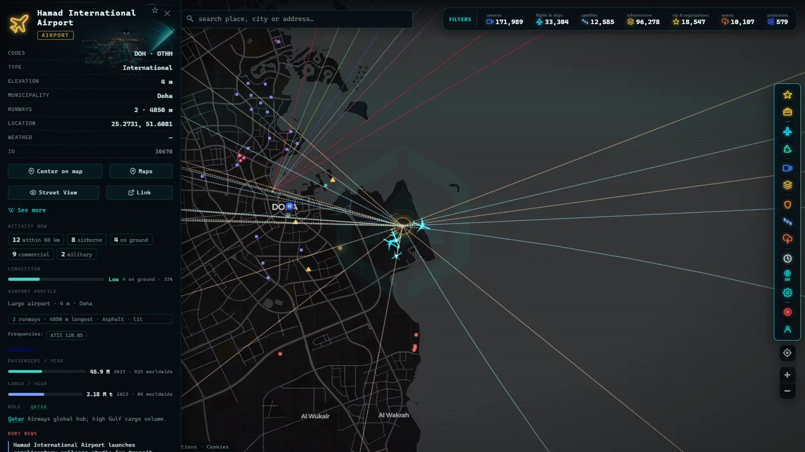
| Hamad International, Doha | DOH | Second Gulf transfer hub, built as a one airport national strategy | Marker plus live traffic, with a dense inbound stream from the west in the early morning | Marker: catalogue. Traffic pattern: what you see live |
| Zayed International, Abu Dhabi | AUH | Third UAE node, close enough to Dubai that both fit on one screen | Marker plus live traffic, frequently sharing approach airspace with Dubai arrivals | Catalogue plus live ADS-B |
| King Abdulaziz, Jeddah | JED | Gateway to Mecca, the only hub on this list whose peak is religious rather than commercial | Marker plus live traffic; the seasonal swing shows up only if you look on the right dates | Catalogue plus live ADS-B |
| King Khalid, Riyadh | RUH | Capital hub of the largest country in the peninsula, being built up as a second national gateway | Marker plus live traffic, with a heavier domestic component than the Gulf city states | Catalogue plus live ADS-B |
| Istanbul | IST | The hinge between Europe, Central Asia and the Gulf, reaching more countries than any single Gulf hub | Marker plus live traffic, and the most visible mix of narrowbodies and widebodies of the six | Catalogue plus live ADS-B |
Two of those columns are editorial and four are mechanical. The role column is written by a human and argued below. The code and the marker come from a static catalogue. The live column is not an opinion at all: it is what the aircraft feed happens to be showing when you open the view, which is why it changes between two visits half an hour apart.
Why the biggest airports in the Middle East are in the desert
Start with the globe rather than the map. From the lower Gulf, a single flight of ordinary long haul length reaches Western Europe, all of India, most of Southeast Asia, the whole of East Africa and the edges of East Asia. Almost nowhere else on earth offers that reach in one hop. Put a connecting bank in the middle of it and you can sell a one stop itinerary between pairs of cities that would otherwise need two stops or a very thin direct route that nobody can fill year round. It also explains the shapes you see on screen, because aircraft do not fly in straight lines and the great circle tracks between Europe and Asia pass startlingly close to these hubs anyway.
Second, and this is the part that surprises people, the small home market is a feature. A European hub has to serve its own city first, and its schedule is shaped by local demand, by slot scarcity and by decades of accumulated point to point routes. A Gulf hub serves passengers who never leave the terminal. Its schedule can be designed purely for connections, arriving in waves from one direction and departing in waves in the other, which is why the arrival stream looks bursty on a live feed instead of evenly spread through the day.
Third, the fleet follows the geometry. If nearly every flight is long haul, you buy long haul aircraft, and a widebody carries several times the passengers of the regional jets that fill much of the European and North American schedule. That is how three airports with modest surrounding populations can beat the movement counts of the busiest airports in Europe in passengers while flying fewer, larger aeroplanes.
Fourth, the institutions point the same way. Airline, airport, air navigation and the ministry granting traffic rights tend to be arms of the same state, so route strategy and capacity planning are one conversation rather than three. There are no night curfews to work around, so the small hours are usable for the long Asian departures, and desert land is cheap and empty, which means a new runway or a whole new terminal is an engineering problem rather than a twenty year planning fight.
None of this makes them weatherproof. Winter fog on the Gulf coast can wreck a morning bank, summer heat cuts payload on the longest departures, and dust events close approaches now and then. What the desert avoids is snow, and the diversions and de-icing queues that come with it.
From the ARGOS ATLAS channel.
What a live map measures at the biggest airports in the Middle East
Our airport layer is a catalogue of 47,927 airports worldwide, from the six hubs above down to gravel strips, and each is a fixed point with a code and a position. The Middle East hubs are simply rows in that table. Nothing about them updates, because runways do not move.
Everything that does move comes from the live layer, and the honest way to describe it is as a snapshot. These are the counts from the snapshot used while writing this article, with the source of each stated plainly.
| Figure | Count | What it actually counts | Source of the column |
|---|---|---|---|
| Airports on the map | 47,927 | Every field in the catalogue, worldwide, not just the Middle East | Static catalogue, count at August 2026 |
| Aircraft in the air | 11,325 | Flights present in the live feed at that moment, worldwide | Live ADS-B snapshot |
| Flagged as estimated | 4,444 | Of those, the ones whose position was not freshly received | Live ADS-B snapshot |
| Military aircraft | 71 | Flights identified as military in that same snapshot | Live ADS-B snapshot |
| Ships being tracked | 21,270 | Vessels with a recent AIS position, worldwide | Live AIS snapshot |
| Ports in the catalogue | 1,081 | Commercial ports, worldwide | Static catalogue, count at August 2026 |
| Sanctioned aircraft flagged | 344 | Airframes on published sanctions lists | Sanctions dataset, count at August 2026 |
| Sanctioned vessels flagged | 1,497 | Ships on published sanctions lists | Sanctions dataset, count at August 2026 |
The maritime rows matter more than they look for this subject. Jebel Ali sits a short drive from Dubai International, and the sea traffic feeding it is visible on the same screen as the aircraft, which is the reason air and sea belong in the same view when you are reading a hub rather than an airport. If that is the thread you want to pull, the piece on the largest ports in the world, live covers the shipping half, and the primer on what critical infrastructure is covers why any of it is public in the first place.
What you will not see, and it is worth saying out loud
There are no public traffic cameras in the Gulf on this map. The catalogue holds 200,000+ cameras (count at September 2026) and its density is European and North American: Spain contributes 10,883, Andalusia alone 1,245, the London area 1,409, Chicago 1,118, New York 999, Miami 941. Not one of the sources feeding that catalogue publishes street cameras in the UAE, Qatar or Saudi Arabia. You can watch a motorway outside Seville in real time and you cannot watch Sheikh Zayed Road. That is a gap in what is published, not a gap we intend to fill by scraping something we should not.
The airport markers are identity and position, nothing more. No passenger totals, no gate assignments, no delay board, no terminal capacity, no cargo tonnage. If you want the annual ranking of the world's largest airports by passengers, that is a different exercise built on published reports, which is what the ranking of the biggest airports in the world is for.
The live layer has its own edges. ADS-B is received by ground stations, so coverage over open desert and open water is thinner at low altitude than it is over dense receiver networks; aircraft at cruise are reliable, an aircraft on final into a hub with few nearby receivers can appear late. In the snapshot above, 4,444 of 11,325 flights carried an estimated position rather than a freshly received one, which means the aircraft is roughly where the marker says and not exactly. Military traffic mostly does not broadcast at all, and 71 military aircraft worldwide in a single snapshot tells you how little of it shows: absence on the map is never evidence of absence in the air.
The practical consequence is that a hub can look empty. It has not closed. Nothing inside your current view is broadcasting at that second.
Istanbul, the hinge counted twice
Istanbul appears in this list and in the European one, and neither placement is wrong. Geographically it is the last European node before Asia. Commercially it does the same job as the Gulf hubs, selling connections between markets that have no reason to fly to Turkey, but from a position several hours further west and with a fleet mixed between short and long haul. That mix lets it feed secondary European and Central Asian cities directly, which the Gulf hubs reach through partners.
On a live map the difference is easy to read. Around European midday the tracks converging on Istanbul come from many directions at once and include a lot of short haul. The Gulf banks are cleaner and more directional, a wall of long haul arriving from the west and then leaving to the east a couple of hours later.
How to check a Gulf hub yourself in two minutes
Open the live map of flights, ships and infrastructure and centre it on the lower Gulf. Dubai and Abu Dhabi will fit in one view, and Doha is a short pan away across the water.
Then do four things. Zoom out until you can see the Strait of Hormuz, because the corridor of traffic through it is the clearest single image of why this region is a junction. Watch the same view twice, a few hours apart, and the wave structure of the arrival banks appears without any analysis. Click an individual aircraft to see what the feed actually holds about it, which is less than most people expect and more than most people realise is public. Finally, switch on the maritime layer over Jebel Ali or Jeddah, and the two halves of the same logistics story sit on one screen.
If a hub looks quiet, note the time in local hours before concluding anything. Gulf schedules are built around night departures and early morning arrivals, and a European afternoon is the middle of their trough.
Frequently asked questions
Which are the biggest airports in the Middle East?
By intercontinental traffic, the short list is Dubai (DXB), Hamad International in Doha (DOH), Zayed International in Abu Dhabi (AUH), King Abdulaziz in Jeddah (JED) and King Khalid in Riyadh (RUH), with Istanbul (IST) acting as the hinge between the region and Europe. We rank them by role in the network, not by passenger totals: those totals are published by airport authorities and we do not measure them ourselves, so we do not quote them as if they were our data.
Is the map free, live and usable without signing up?
Yes. The map is free, needs no account and no registration, and the aircraft layer is live rather than a replay. What you see is the current position feed, with the caveat that some positions are flagged as estimated between reports and that an aircraft not broadcasting does not appear at all.
Can I watch traffic cameras in Dubai or Doha?
No. The camera catalogue holds 200,000+ public cameras (count at September 2026) and its density sits in Europe and North America, with Spain (10,883), the London area (1,409), Chicago (1,118), New York (999) and Miami (941). None of the sources feeding it publishes cameras in the Gulf, so there is no live view of Sheikh Zayed Road or of the Doha ring roads.
Why do Gulf hubs move so much traffic with such small home markets?
Because almost none of their traffic starts or ends there. They sell connections rather than destinations, and their position lets a single stop join Europe with South and Southeast Asia, Africa with East Asia, and Australia with almost anywhere. The airport is a junction, and the size of the surrounding city is close to irrelevant to that business.
Does an empty airport on the map mean the airport is closed?
No, and this is the most common misreading. The airport marker comes from a static catalogue of 47,927 airports and is always there. Aircraft come from a live feed, so a hub with no aircraft on screen usually means nothing is broadcasting inside your current view at that second, not that operations have stopped.
- Italy Airports Live Map: 4 Fields and What They Hide
- Mumbai live map: ships, flights and port data in real time
- Philippines Airports Live Map: Manila, Clark, Cebu, Davao
- Poland Airports Live Map: Chopin, Gdansk, Krakow and More
- India Airports Live Map: Delhi, Mumbai, Hyderabad, Chennai
- Iraq Airports Live Map: Baghdad, Erbil, Kirkuk and Basra