Blog · Critical infrastructure
Philippines Airports Live Map: Manila, Clark, Cebu, Davao
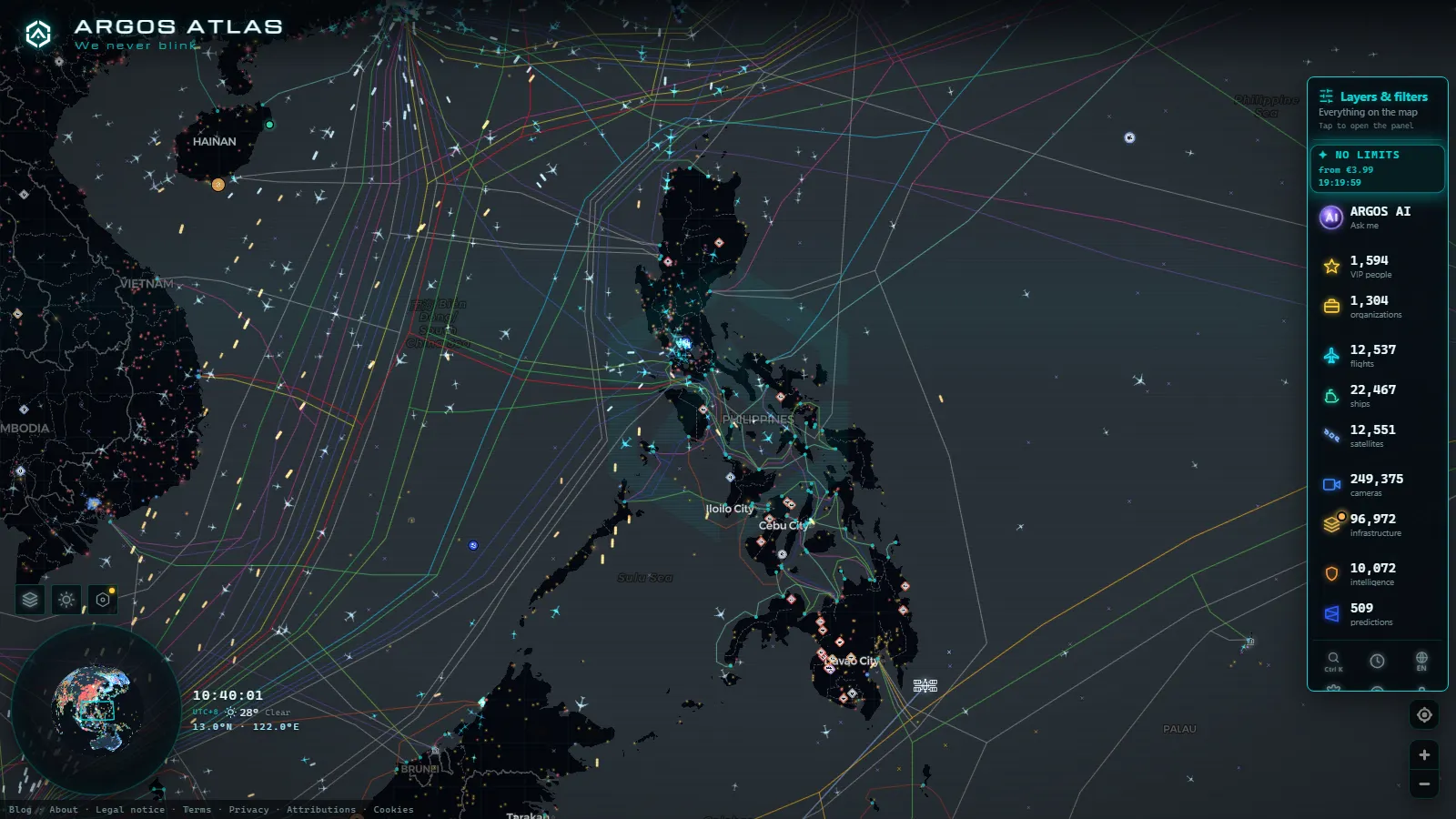
Four airports carry almost all of the traffic you will see over the Philippines, and all four are already on the map: Ninoy Aquino in Manila (RPLL / MNL), Clark in Pampanga (RPLC / CRK), Mactan-Cebu (RPVM / CEB) and Davao (RPMD / DVO). It is free, there is no account, and the airport cards open with one click inside a catalogue of 47,927 airports and roughly 13,229 aircraft tracked in the air at once (counts at September 2026).
This is not a ranking of the world's biggest terminals. It is how to read an archipelago. 114,123,600 people live across thousands of islands with only 342,353 km² of land between them, so between most of those islands the plane is not a luxury, it is the road. Open the live world map, zoom on Luzon, and the pattern shows up in seconds: a dense knot over Manila Bay, then thin single threads running south.
The essentials, in 20 seconds
- Ninoy Aquino (RPLL / MNL) is the first card to open: it is one of the fullest airport cards in the product, with position, runway layout and the live traffic around it.
- Clark (RPLC / CRK) shares one card with Clark Air Base, so the same field reads as civil airport and military installation at once.
- Mactan-Cebu (RPVM / CEB) and Davao (RPMD / DVO) are reached from the map search by name, not from a card on this page.
- The flight layer holds 13,229 live flights, of which 282 are flagged military and 4,139 are estimated positions rather than confirmed ones (count at September 2026).
- Public street cameras exist on Luzon, but none of them points at a runway: there is no public airfield camera in the Philippines.
Ninoy Aquino: the card worth opening first
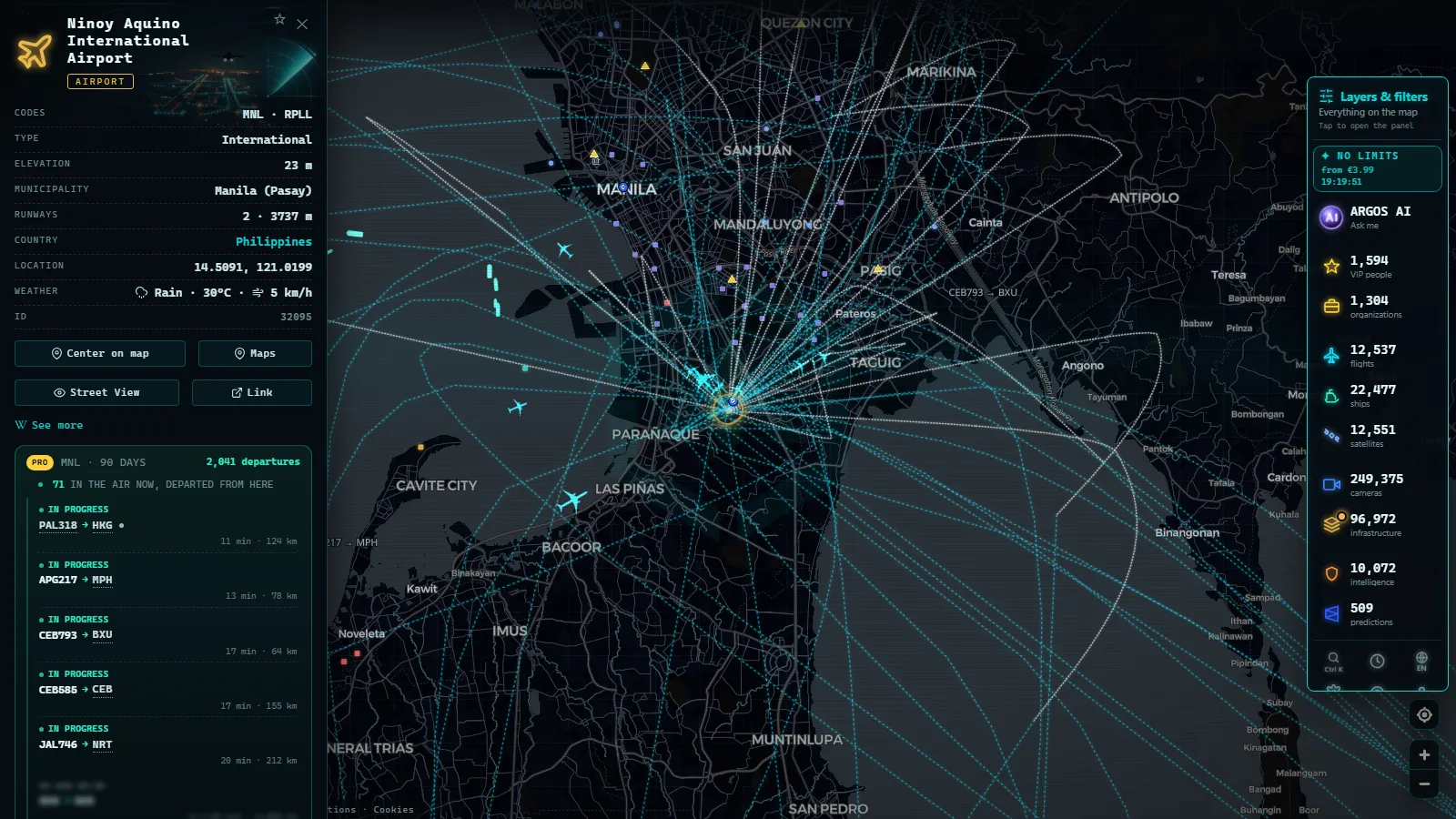
Manila's airport sits inside the city, wedged between Pasay and Parañaque, which is why it looks strange on the map: the runways end where the streets begin. Two strips cross (06/24 and the shorter 13/31), so in practice it works as a single-runway airport, and that one line serves the whole of Metro Manila. Open the card and you get RPLL, MNL, the exact position, the runway geometry and whatever is airborne around it at that second.
It is the fullest of the four, and the best place to learn what the flight layer can and cannot tell you. Watch it early in the morning and the shape of the day appears: the departure wave to the provinces first, then long-haul arrivals from the Gulf and East Asia stacking over the bay.
Clark: the runway with room to grow
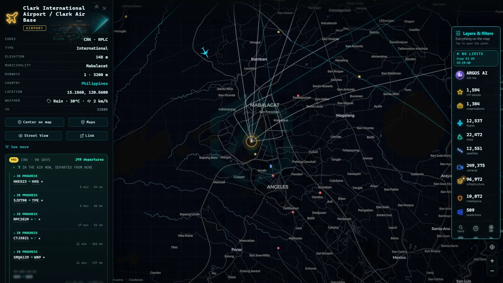
Clark, in Pampanga north of Manila, is the release valve. Its card is one of the more interesting ones in the product because it is filed as Clark International Airport / Clark Air Base: the same field is a civil airport and a military installation, and the map does not pretend otherwise.
That matters when you read traffic there. A movement can be a low-cost flight to Incheon, or something with no commercial flight number at all. The map flags 282 aircraft as military worldwide (count at September 2026), and Luzon is one of the places where you will occasionally catch one. Just outside the perimeter, Angeles has public street cameras, so you can watch the city the airport feeds even though the apron itself is invisible.
From the ARGOS ATLAS channel.
Mactan-Cebu: the gateway to the Visayas
Mactan-Cebu (RPVM / CEB) is the second busiest field in the country and the one that makes the archipelago legible. It sits on Mactan, in Lapu-Lapu City, across a bridge from Cebu City, and it feeds the central islands the way Manila feeds Luzon: domestic hops to Bohol, Leyte and the Visayan ports, plus direct flights to Korea, Japan and Singapore that never touch Manila.
On the map its card is thinner than Manila's, so the useful signal is the traffic, not the card. Type Mactan-Cebu into the map search, then read the tracks: short legs radiating outward at low altitude are the island network, and a single line crossing the Sulu Sea at cruise height is usually an international arrival. The Cebu port card sits a few kilometres away, which is the second half of how these islands move goods.
Davao: how Mindanao stays connected
Davao (RPMD / DVO), the Francisco Bangoy field serving Davao City, is the southern anchor. There is no rail spine down Mindanao and the sea routes are slow, so the Manila and Cebu legs are the connection, and that is exactly what you see on the map: a thin, steady pair of corridors rather than a busy cluster.
Davao is also where the honest limits of the flight layer show up soonest. Coverage over Mindanao and the seas around it is thinner than over Luzon, so a track can freeze for a stretch and then jump. When it does, you are looking at an estimate, not a report. Read the card for the codes and position, and read the traffic as a pattern over minutes instead of trusting any one aircraft's exact dot.
What the philippines airports live map shows, airport by airport
Four cards, one table. The last column is the part worth keeping: each field answers a different question, and opening the wrong one wastes the click.
| Airport | Codes | What it is on the map | What to watch for |
|---|---|---|---|
| Ninoy Aquino, Manila | RPLL / MNL | Full card, position and runways | The morning provincial wave and the long-haul stack |
| Clark, Pampanga | RPLC / CRK | One card, civil airport plus air base | Movements with no commercial flight number |
| Subic Bay | RPLB / SFS | Card kept with its naval air station name | Cargo and irregular traffic, not scheduled flights |
| Mactan-Cebu | RPVM / CEB | Found by name in the map search | Short island legs radiating out at low altitude |
| Davao | RPMD / DVO | Found by name in the map search | Corridor traffic to Manila and Cebu, and coverage gaps |
Street cameras on Luzon: what the ground gives you
The Philippines is a country with plenty of live flight data and very little public camera data, and it is worth being blunt about that. What exists is a handful of street and weather cameras on Luzon, mostly around Metro Manila and Central Luzon. They are useful for a different question than the airports: not what is flying, but whether the road to the terminal is moving.
The featured one, in Mandaluyong, is Metro Manila traffic at street level. Kaunlaran adds a second city angle, the Angeles camera sits beside the city that grew around Clark, and a Luzon weather station gives conditions rather than a scene. Nothing here shows an aircraft.
The port beside the runway
Airports are only half of a Philippine logistics picture. The map carries 1,081 ports and about 22,625 ships reporting positions (counts at September 2026), and in Luzon the two layers sit almost on top of each other: the Manila port card is minutes from the airport, and Subic Bay pairs a deepwater port with its own airfield.
The power layer completes it. 34,936 power installations are catalogued worldwide, and around Manila Bay the ones to open are Limay and MALAYA, oil and coal plants that keep the terminals and the container cranes running. If you want the reasoning behind why all of this is mapped in public at all, the piece on what critical infrastructure is covers it.
Why an archipelago reads differently on a flight map
On a continental map, air traffic is a layer on top of roads and rail. Here it is the network itself. That changes what a live view is good for: the useful reading is not one aircraft but the density of short legs between islands, which is a direct picture of how the country connects on a given morning.
It also explains the gaps. ADS-B needs receivers on the ground, and the ground is often water, so the archipelago produces more estimated positions than a place like Western Europe. The tracking layer itself is explained in the guide to how ADS-B flight tracking works, and the mechanics are the same everywhere: the aircraft broadcasts, someone has to be listening.
Philippines · Internet users
What you won't see
- No runway cameras. There is no public airfield camera in the Philippines, so no landings, no aprons, no taxiways. For places where those exist, see the roundup of airport webcams in the live map.
- Frames, not video. Street cameras deliver still images that refresh, not a stream, and the interval is set by the operator, not by us.
- No people, no plates. The resolution of these public cameras does not identify faces or number plates, and nothing here is stored to build a history.
- Night drops out. Unlit street cameras go dark or noisy after sunset, and some simply stop returning an image until morning.
- No passenger figures, no schedules. The cards hold identity and position, not timetables or annual traffic. For comparative scale, the ranking of the world's biggest airports is the right page.
- Gaps over water. Tracks between the islands can freeze and jump, because 4,139 positions on the map are estimated rather than confirmed (count at September 2026).
Working the philippines airports live map in two minutes
Start at Manila. Open the map of live airports and flights, find Ninoy Aquino, and read the card before touching anything else: it sets your expectation for what the other three will and will not have. Then pull back until Luzon and the Visayas are both on screen.
From there, do three things. Follow one short domestic leg end to end, so you learn how a track behaves when coverage thins. Open Clark and check whether anything on its apron lacks a flight number. Finally, look at the Manila port card next to the airport, because the two together are the actual bottleneck of the country. That is the whole reading, and it takes about as long as the departure wave.
Frequently asked questions
Is the Philippines airports live map free?
Yes, and there is no sign-up. The map opens in a browser, the airport cards for Ninoy Aquino, Clark and Subic Bay load without an account, and live aircraft positions refresh on their own. Nothing is paywalled to see the four main Philippine airports or the street cameras on Luzon.
Can I see planes landing at Ninoy Aquino on a camera?
No. There is no public runway camera at any Philippine airport, so what you get is the aircraft track on the map plus the airport card, not a picture of the threshold. The closest live images are street cameras in Metro Manila and Angeles, which show city traffic rather than aviation.
Why do some flights over the islands disappear?
Because ADS-B coverage depends on ground receivers, and the central Philippines has long stretches of open water with none. A flight that leaves receiver range stops reporting until it comes back in. Of the positions on the map, 4,139 are estimated rather than confirmed (count at September 2026), and those are the ones that drift.
Which Philippine airport has the best card on the map?
Ninoy Aquino, by a distance. Its card carries the codes RPLL and MNL, the position, the runway layout and the traffic around it, which is why it is worth the first click. Clark is the second best because its card doubles as Clark Air Base, and Subic Bay carries its naval air station history.
Are Mactan-Cebu and Davao on the map too?
Yes, both are in the catalogue of 47,927 airports, but you reach them through the map search by typing Mactan-Cebu or Davao rather than from a link here. Their cards are thinner than Manila's, and the useful signal around them is the aircraft traffic, especially the domestic hops toward Mindanao and the Visayas.
- Poland Airports Live Map: Chopin, Gdansk, Krakow and More
- India Airports Live Map: Delhi, Mumbai, Hyderabad, Chennai
- Iraq Airports Live Map: Baghdad, Erbil, Kirkuk and Basra
- Colombia Airports Live Map: What El Dorado, MDE and CLO Show
- Data Center Map: 4,072 Sites and What You Can Actually See
- South America Airports Live Map: Bogotá, Lima, Buenos Aires