Blog · Critical infrastructure
Italy Airports Live Map: 4 Fields and What They Hide
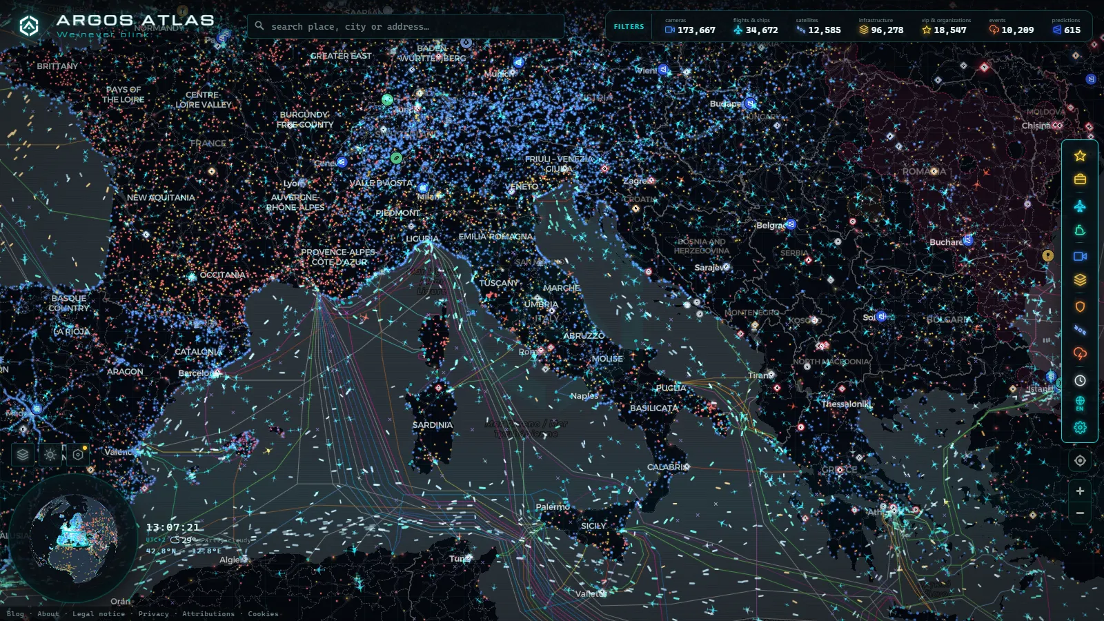
Open a flight tracker over Italy on a weekday morning and the peninsula draws itself: a knot of traffic over Lombardy, a second one over Lazio, and a thinner line running south towards Sicily and Malta. That shape is not a quirk of the rendering. It is what a handful of airports do to a country's sky.
This is the live sheet for the four that dominate that picture: Malpensa, Fiumicino, Capodichino and Orio al Serio. It is not another ranking (we already have one for the busiest airports in Europe). It is what each field looks like while it is moving, how to tell them apart at a glance, and what the map quietly leaves out.
The essentials, in 20 seconds
- Malpensa, Fiumicino, Capodichino and Orio al Serio: the four Italian fields this live map is built to compare side by side.
- 12,430 aircraft: tracked worldwide in the snapshot behind this article, with 229 flagged as military.
- 3,831 aircraft: shown from an estimated position rather than a freshly received one.
- 47,927 airfields: catalogued underneath the map, from the big hubs down to grass strips and heliports.
- Capodichino: Naples' single runway sits inside the built-up city, with approaches passing low over rooftops.
What the Italy airports live map actually shows
Every aircraft dot comes from the aircraft itself. ADS-B is a broadcast: the transponder announces position, altitude, speed and identity several times a minute, and any ground receiver within line of sight picks it up. Nobody asks the airline for permission, and nothing on the map's side is radar. That is why coverage is excellent over flat, populated ground, patchy over the Tyrrhenian, and thin along the Alpine ridge.
In the snapshot behind this article the system was following 12,430 aircraft worldwide, 229 of them flagged as military, and 3,831 shown from an estimated position rather than a freshly received one. That last figure is the honest part of any tracker: an estimated dot is a plausible dot, not a measured one. Underneath sits a catalogue of 47,927 airfields, which is why zooming into Lombardy or Puglia keeps surfacing grass strips and heliports you have never heard of next to the big names.
If you want the mechanics of the signal before the geography, the guide on how to watch aircraft in real time covers the transponder side properly.
The four Italian fields side by side
The fastest way to read Italian traffic is to know what each field is for. Milan and Rome both split their traffic across two airports, and the split is the whole story.
| Field | Codes | Serves | Traffic character | What to watch on the map |
|---|---|---|---|---|
| Malpensa | LIMC / MXP | Milan, long haul | Intercontinental plus Italy's heaviest freight operation | Wide bodies stacking in from the north west in the morning |
| Linate | LIML / LIN | Milan, city | Short haul, slot constrained, business jets | Dense, fast turnarounds close to the city centre |
| Fiumicino | LIRF / FCO | Rome | The country's main hub, biggest runway system | Arrival banks from the sea, then a wave of departures |
| Ciampino | LIRA / CIA | Rome, secondary | Low cost, express freight, business and state flights | Small, irregular, high proportion of odd callsigns |
| Capodichino | LIRN / NAP | Naples | Single runway inside the built-up city | Approaches over rooftops, sharp summer peaks |
| Orio al Serio | LIME / BGY | Bergamo and Milan's low cost half | Point to point plus a night express freight wave | Activity after midnight, when Malpensa has gone quiet |
From the ARGOS ATLAS channel.
Malpensa: where Milan sends its long routes
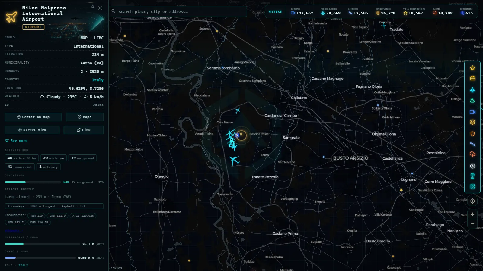
Malpensa sits out in the Ticino valley, well away from Milan, on two parallel strips that run more or less north to south. On the map it reads as a funnel: the intercontinental arrivals converge from the north west through the morning, and the field keeps working after the passenger peak because it carries the heaviest air freight operation in the country.
The tell is aircraft type. Malpensa is where you see the big metal, and where a track that started over the Atlantic or the Gulf finally comes to rest. Watch the runway direction flip when the wind turns and the whole approach pattern rotates within a few minutes: the inbound tracks that were coming down from the north swing around and start feeding in from the south instead.
Linate is the other half of the same city. Close in, one runway, strictly limited slots, and a constant churn of short European hops and business jets. Two airports, two completely different signatures, roughly forty kilometres apart on your screen.
Fiumicino: the rhythm of a real hub
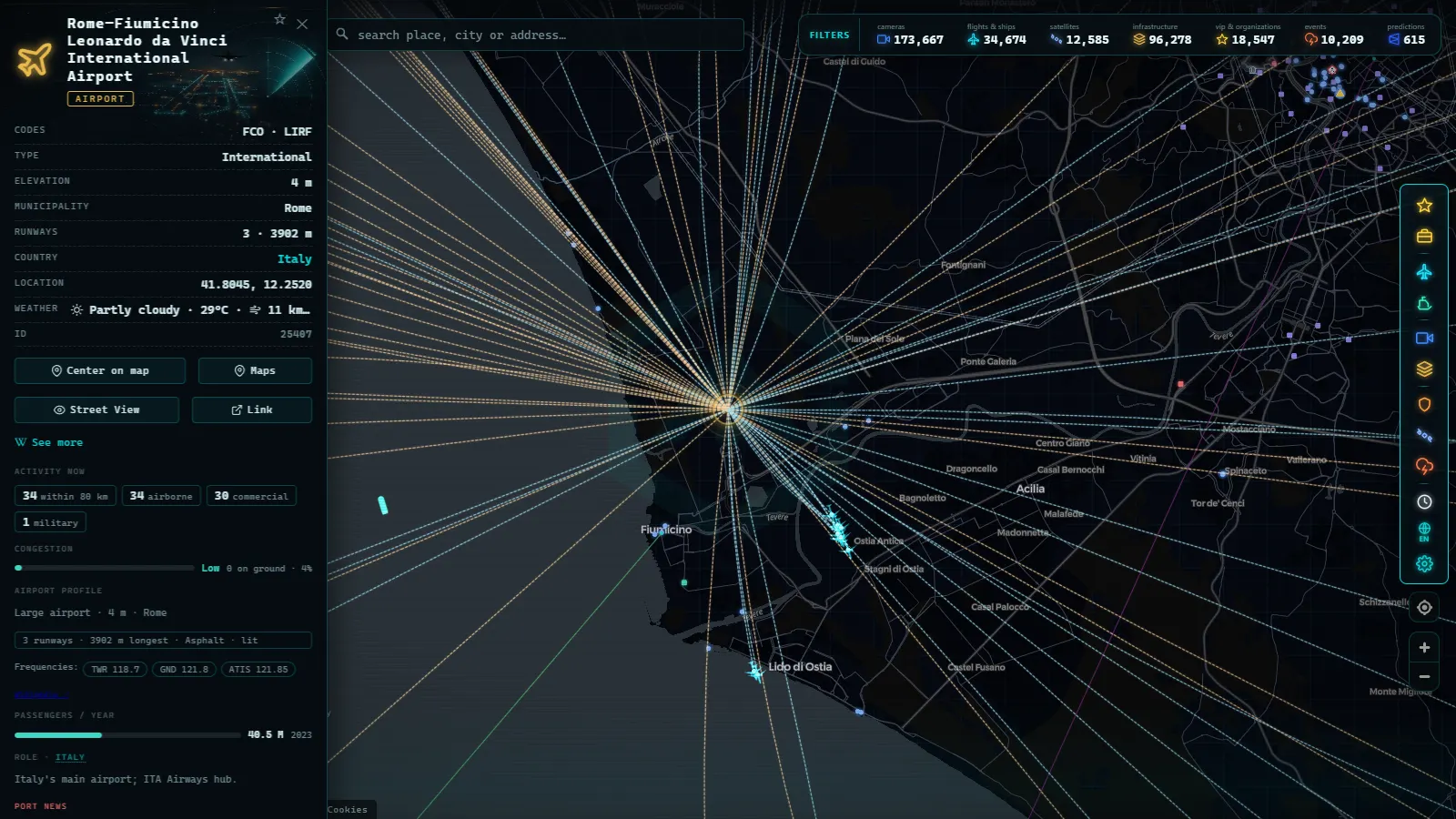
Rome Fiumicino is on the coast at the Tiber delta, and most of its arrivals come in over the sea. That geography is a gift for tracking: over water there is nothing to block the signal from the receivers along the shore, so tracks stay clean almost to the threshold.
What distinguishes Fiumicino from Malpensa on the map is structure. It behaves like a hub, which means it breathes in banks: a cluster of arrivals lands within a narrow window, sits on the ground, and then a cluster of departures leaves together. Zoom out and you can watch the whole thing inhale and exhale a few times a day. Malpensa's pattern is flatter and more continuous.
Ciampino, on the other side of Rome, is the interesting one for anyone reading callsigns. Low cost, express cargo, business aviation and state flights share a small field, which is why its traffic looks scattered and irregular next to Fiumicino's metronome.
Capodichino: one runway, and a city all around it
Naples Capodichino is the most visually striking of the four because it is genuinely inside the city. A single runway, buildings right up to the fence, hills to the north, and approaches that pass low over rooftops. Its traffic swings hard with the season: heavy in summer, much quieter in the winter months.
It is also where the map's limits show up first. Aircraft on short final drop below the line of sight of the nearest receivers and their tracks simply stop, a few kilometres out, every single time. Nothing is broken. The signal just cannot bend around terrain. Capodichino also has a military side, and that traffic appears on the map only when it chooses to broadcast.
Orio al Serio: the airport that works at night
Bergamo Orio al Serio is the reason the Italian map is not empty at three in the morning. One runway, a big low cost base, and an express freight operation that loads and leaves when everything else has stopped. Night movements there are limited and locally contested, but the cargo wave is real, and it is the single best thing to watch if you want to see how differently an airport behaves outside daylight hours.
Side by side over a full day, Malpensa peaks in the morning, Fiumicino pulses in banks, Capodichino follows the holiday calendar, and Orio al Serio fills the gap the other three leave.
What the Italy airports live map does not show
This is the part most trackers skip, so here it is plainly.
- Aircraft without a transponder. Gliders, ultralights, older general aviation and many helicopters broadcast nothing usable. A busy flying club afternoon over the Po valley can be invisible.
- Most military activity. Only 229 flights worldwide were flagged as military in the snapshot above. Transports and tankers often broadcast; tactical flights generally do not. An empty patch of sky is not evidence of an empty sky.
- Masked identities. Some operators use programmes that anonymise the registration and operator, so the aircraft moves but carries no name. That is the norm rather than the exception in business aviation, as the piece on how private jets are tracked explains.
- Anything below the receiver horizon. Ground movements, taxiing and the last stretch of an approach into a field surrounded by terrain are usually missing.
- Live runway video. There is none. Italy's public camera layer belongs to the motorway operators and points at roads, which is the subject of the guide to traffic cameras in Italy. Across the whole product there are 200,000+ public cameras (count as of September 2026) and not one of them looks at an Italian runway. Airfield views are a different kind of feed altogether, covered in the piece on airport webcams, and they are almost always a still image refreshed every few minutes, not video.
Reading the Italy airports live map like a regular
A few habits that make the difference between staring at dots and actually seeing something:
- Click a single aircraft and follow its whole track. The route tells you more than the label: an arrival that has come down the Rhone valley behaves nothing like one that crossed from the Adriatic.
- Watch the runway direction change. When the wind flips, every approach path rotates. It is the clearest live demonstration that these are real aircraft and not a simulation.
- Compare two airports at once. Put Malpensa and Orio al Serio in the same view and the division of labour between them becomes obvious within an hour.
- Check the same view at night. Half the character of an airport only appears when the passenger schedule has stopped.
- Treat an estimated position as a hint. When a dot is being extrapolated rather than measured, it is a guess with good manners.
The fastest way in is simply to zoom into northern Italy on the live map of flights and airports and let the pattern build for ten minutes. Aircraft first, then the airport layer, then the question of what is missing. That last one is the habit worth keeping.
Frequently asked questions
Is the Italy airports live map free, and do I need an account?
It is free and there is no signup. Open the map, zoom to northern Italy or Rome, and the aircraft are already moving. No email, no trial, no paywalled layer for the flight view. The same applies to the airport catalogue and the camera layers.
Why do some aircraft disappear on final approach at Naples Capodichino?
ADS-B needs line of sight to a ground receiver. Low over a city ringed by hills, an aircraft drops below the horizon of the nearest receiver and the track stops before touchdown. It is a geometry problem, not a data outage, and it happens at almost every airport surrounded by terrain.
Can I see the aircraft registration of every private jet at Ciampino?
No. Some operators use identity masking programmes that replace the registration and operator with a generic label, so the dot moves but the name is blank or anonymised. Business aviation is where you notice it most, and Ciampino and Linate are where it shows up in Italy.
Are Italian military flights shown on the map?
Only the ones broadcasting openly. In the snapshot used here, 229 flights worldwide were flagged as military, a tiny slice of the total. Transport and tanker aircraft often broadcast; tactical flights and anything on an operational mission usually do not. Absence on the map proves nothing about the sky.
Is there live video of the runways at Malpensa or Fiumicino?
Not on this map. The Italian camera layer comes from motorway operators and points at roads, not at airfields. Airport webcams exist elsewhere as a separate kind of feed, usually a still image refreshed every few minutes rather than continuous video.
- Mumbai live map: ships, flights and port data in real time
- Philippines Airports Live Map: Manila, Clark, Cebu, Davao
- Poland Airports Live Map: Chopin, Gdansk, Krakow and More
- India Airports Live Map: Delhi, Mumbai, Hyderabad, Chennai
- Iraq Airports Live Map: Baghdad, Erbil, Kirkuk and Basra
- Colombia Airports Live Map: What El Dorado, MDE and CLO Show