Blog · Critical infrastructure
Colombia Airports Live Map: What El Dorado, MDE and CLO Show
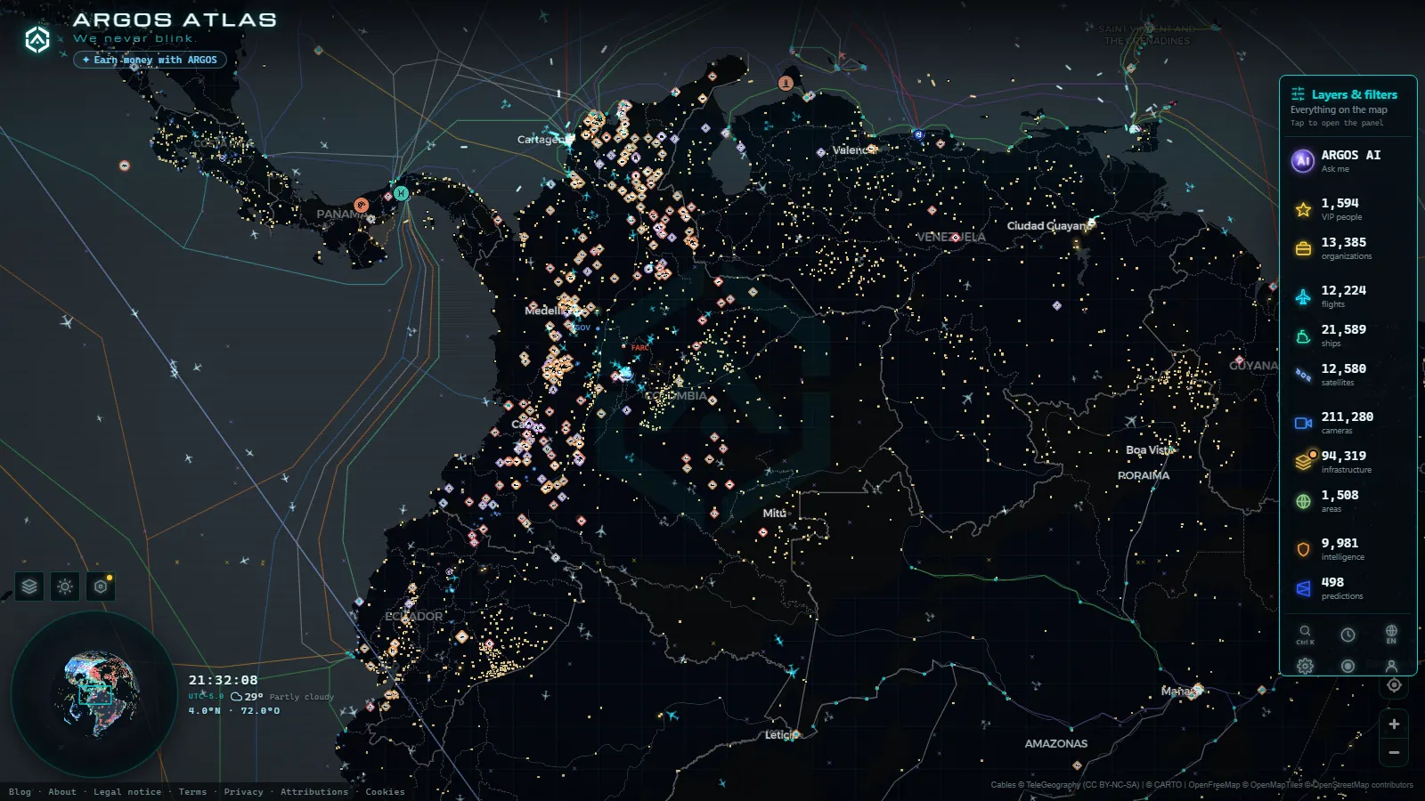
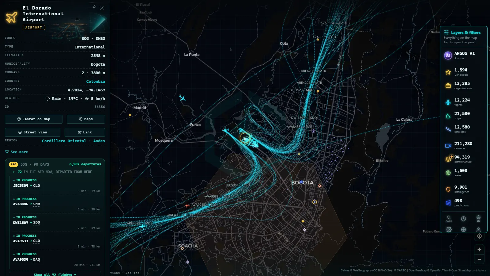
Colombia's airspace on the live map is two things stacked on each other: an ADS-B flight layer that moves, and a fixed catalogue of airport cards that does not. Pan across the savanna around Bogotá on the live airspace map and you see aircraft in near real time; click the El Dorado card and you get identity and position (codes, coordinates, the exact spot on the ground), not a departure board. Both are free, and neither asks you to register.
What follows goes airport by airport: El Dorado as the gate for cargo and passengers, Rionegro for Medellín, Cali and the Pacific, the Caribbean strips, and the bases and short runways people keep clicking on. It says which cards carry live flights and which stay static, and how to tell an IATA code from an aircraft registration, the mix-up that catches almost everyone in a first session with the layer.
The essentials, in 20 seconds
- El Dorado (BOG / SKBO) is the busiest card in the country, with passengers and freight sharing the same pair of parallel runways.
- José María Córdova (MDE / SKRG) is in Rionegro, over a mountain from Medellín. The runway inside the city is Olaya Herrera (EOH), a different airport with its own card.
- One global snapshot held 12,613 aircraft aloft, 220 of them flagged military and 4,199 on estimated tracks instead of fresh positions (snapshot of October 2026).
- The catalogue carries 47,927 airports, so Colombian strips with no scheduled service still get a card.
- Free and with no account: the flight layer refreshes on its own, the cameras are stills rather than video, and nothing is gated.
El Dorado (BOG): the gate for cargo and passengers
El Dorado sits high on the Bogotá savanna, and altitude is the first thing that explains its traffic: long takeoff rolls, performance limits, and a shortlist of what can leave fully loaded. It is the country's main passenger gate and, less obviously, its main freight gate, with flowers and perishables going out and e-commerce coming in.
On the map that shows up as rhythm, not as a figure. Overnight the shapes holding over the savanna skew towards widebody freighters; mid-morning it is domestic narrowbodies fanning out to Rionegro, Cali and Cartagena. Avianca callsigns start with AVA, so a line of AVA targets converging from three bearings is usually the domestic wave arriving at once. Zoom in and the two parallel runways make it easy to separate the arrival flow from the departure flow by eye.
Rionegro (MDE): Medellín's airport is not in Medellín
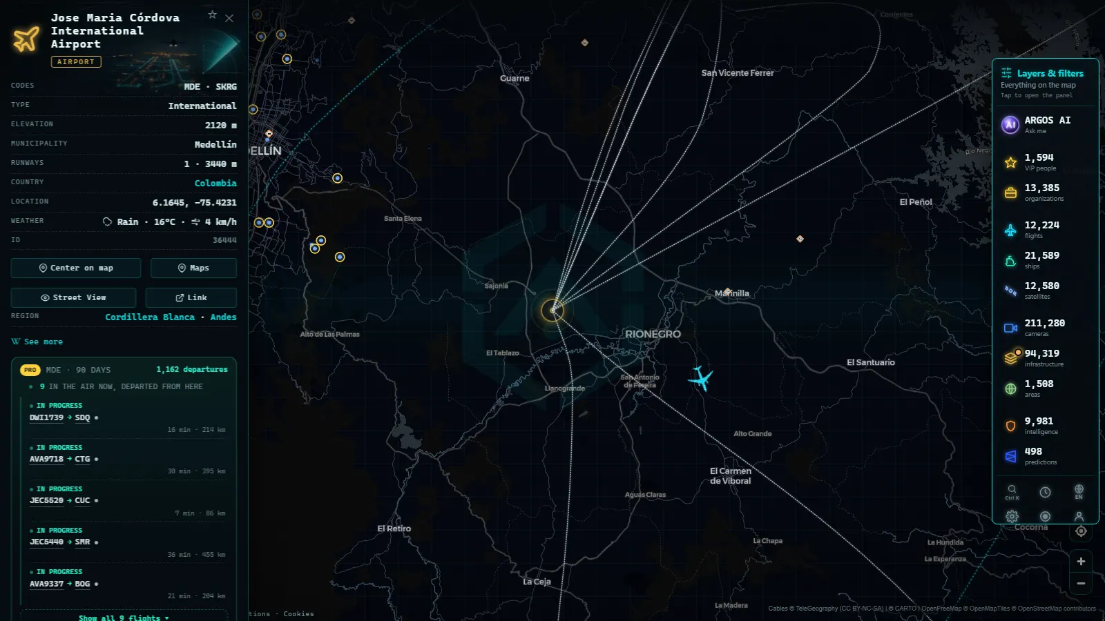
This is the most useful thing to know before you search. José María Córdova, code MDE, ICAO SKRG, is in Rionegro in eastern Antioquia, on a plateau reached by a mountain road and a tunnel. The strip inside the city, Olaya Herrera, is short, hemmed in by the valley walls, and handles regional turboprops.
Low cloud on the plateau is part of reading this card: watch arrivals long enough and you see aircraft hold, go around, or divert to El Dorado. The camera above, on the Santa Elena road between the city and the plateau, is the ground-level companion to that. When it is white, the plateau is in cloud. The road cameras down in the valley are a separate story, covered in the guide to traffic cameras in Medellín.
From the ARGOS ATLAS channel.
Cali (CLO) and the Pacific corridor
Alfonso Bonilla Aragón is the Cali card, and like Rionegro it is not in the city it serves: it sits in Palmira, out in the flat cane country of Valle del Cauca. Code CLO, ICAO SKCL.
What makes it interesting on a live layer is direction. Traffic here leans south and west, towards Quito, Guayaquil and Lima, plus the shuttle to Bogotá and the cargo rotations feeding the flower and fruit chains. Much of what lands as freight continues overland to the Pacific terminal at Buenaventura, which is why the airport card and the port card are often worth having open together. Cali also anchors the regional strips at Armenia, Pereira and Popayán, whose cards exist but whose traffic is thin enough that an empty sky is normal rather than a fault.
The Caribbean coast: Cartagena, Barranquilla and San Andrés
The coast is where tourist traffic and port traffic overlap. Rafael Núñez (CTG / SKCG) sits unusually close to the centre of Cartagena, so approaches run over the bay and the walled city. Ernesto Cortissoz (BAQ / SKBQ) serves Barranquilla from Soledad, Simón Bolívar serves Santa Marta, and Gustavo Rojas Pinilla (ADZ) sits on San Andrés in the western Caribbean, the one Colombian card where nearly every arrival has crossed open water.
Put the airspace next to the sea layer here. With ships switched on, the approach into Cartagena shows aircraft and anchored vessels in the same frame, which is the clearest picture of a single city handling two kinds of traffic at once.
Bases and the small runways people keep opening
Plenty of the clicking on Colombian airspace lands on cards that are not commercial airports: air force bases such as Palanquero (SKPQ) at Puerto Salgar and Apiay (SKAP) near Villavicencio, plus the departmental strips of Casanare, Meta, Vichada and Amazonas, including Leticia (LET / SKLT) on the river.
Honesty matters more than coverage here. The card exists because the runway exists in the database, not because traffic over it is visible. State aircraft are not required to broadcast ADS-B, and many do not, so the realistic result of opening a base card is an accurate location with quiet sky above it. The 220 aircraft flagged military in a global snapshot (October 2026) is the entire worldwide slice, which tells you how little of this layer is military.
IATA code against registration: how to read what you clicked
Three letters is an IATA code and it belongs to a place: BOG, MDE, CLO, CTG. Four letters is an ICAO code, also a place, but the first two letters say where in the world: every Colombian aerodrome starts with SK, hence SKBO, SKRG, SKCL.
A registration belongs to an aircraft rather than a place, and Colombian civil registrations begin with HK. It is painted on the fuselage and stays with the airframe for years. A callsign is the third thing and belongs to the flight: an airline prefix plus digits, like AVA and a number, changing daily. So the target you clicked may be showing you a callsign while the card you clicked is showing you a place. The long version is in how to identify a plane from its registration and callsign.
Which cards carry live flights and which do not
| Card | Codes | What the card actually gives you | When to open it |
|---|---|---|---|
| El Dorado, Bogotá | BOG / SKBO | Position and codes, dense live traffic overhead | Overnight, to watch the freight pattern |
| José María Córdova, Rionegro | MDE / SKRG | Position and codes, live traffic on the plateau | When cloud starts pushing arrivals around |
| Alfonso Bonilla Aragón, Palmira | CLO / SKCL | Position and codes, live traffic heading south | To follow the Quito and Lima corridor |
| Rafael Núñez, Cartagena | CTG / SKCG | Position and codes, live traffic over the bay | With ships on, for port and approach together |
| Leticia and departmental strips | LET / SKLT and others | Position and codes, often empty sky | To locate a runway you heard named in the news |
| Air force bases | SKPQ, SKAP | Position and codes, traffic rarely visible | To check where a base is, not what flies from it |
The pattern is simple: the card is static and accurate about where something sits, while the movement comes from the flight layer above it, and that layer only ever draws aircraft that are broadcasting. To practise reading it anywhere, the walkthrough on how to see planes in real time is the shortest way in.
Coverage over the Andes, and where it thins out
ADS-B reception is line of sight, and Colombia is one of the harder countries in the Americas for it: three cordilleras, deep valleys, and an Amazon basin with few receivers. A jet cruising between Bogotá and Cali is solid; the same route flown low by a turboprop drops in and out. When reception stops, a target can be carried for a while on a computed track, which is what those 4,199 estimated positions in the October 2026 snapshot represent globally.
Volcanic ash is the other Colombian variable, and Nevado del Ruiz is the one to watch, since its plumes have rerouted traffic over the coffee region before. Its observatory cameras sit on the map beside the airport cards, in the same catalogue that holds 211,280 cameras (count as of October 2026).
What you won't see
- No departure boards. Airport cards carry identity, codes and position. Scheduled times, gates, delays and passenger figures are not in them.
- No video. The cameras near these airports, including the Santa Elena one above and the Nevado del Ruiz feeds, are still frames that refresh, not streams.
- No people and no number plates. Public camera framing and resolution do not identify individuals or read plates, and nothing in the layer is built to.
- No reliable military traffic. Base cards show locations; aircraft that do not broadcast, or that filter their identity, are simply absent.
- Gaps and outages. Receivers drop out, cameras go dark at night or freeze on their last frame, and Amazonian and Pacific coverage is thinner than Andean coverage.
- No replay. What you are looking at is now, not last Tuesday.
Two minutes on the map, in order
Start wide and come down. Open the live map, bring Colombia into view with flights on, and let the targets tell you where the traffic is before you touch a single card: the savanna, the plateau east of Medellín, Valle del Cauca, the Caribbean approach. Then click the three big cards (SKBO, SKRG, SKCL) to pin the geography, and only then hunt for the strip you actually came for. That order keeps you clear of the two classic errors: treating MDE as a city airport, and reading quiet sky over a base as a broken map rather than as aircraft that are not broadcasting.
Frequently asked questions
Is the Colombia airports live map free, live and open without registration?
Yes. The flight layer and the airport cards are open to anyone with a browser, with no account and no trial. Positions refresh on their own while the tab stays open, so you watch aircraft move rather than reload a page. The cameras in the same view are still frames, not video, and they refresh on their own schedule.
Does the El Dorado card show arrivals and departures?
No. The El Dorado card gives you identity and location: IATA BOG, ICAO SKBO, coordinates and the exact spot it occupies on the map. Scheduled times, gates and delays are not in it. What you do get live is the traffic around it, because the ADS-B layer draws every aircraft broadcasting overhead.
Why do aircraft disappear from the map over the Andes?
Because ADS-B is line of sight. Aircraft positions reach the map through ground receivers, and ridges, valleys and the Amazon basin block that path at low altitude. When the signal stops, the layer can hold a target on an estimated track for a while, then drops it. A cruising jet stays visible far longer than a turboprop in a valley.
Is MDE the airport inside Medellín?
No. José María Córdova (MDE, ICAO SKRG) is in Rionegro, on the plateau east of the city, and the drive crosses a mountain. The airport inside Medellín is Olaya Herrera (EOH), a short city runway used by regional turboprops. Searching for Medellín returns both, so check the ICAO code before you decide.
Can I watch Colombian military flights on the map?
Rarely, and never completely. State aircraft are not obliged to broadcast ADS-B, and many switch the transponder off or filter their identity, so a base card can sit there with empty sky above it. A global snapshot flagged 220 aircraft as military in October 2026, worldwide, which tells you how thin that slice is.
- Data Center Map: 4,072 Sites and What You Can Actually See
- South America Airports Live Map: Bogotá, Lima, Buenos Aires
- Data centers in Mexico: the 4 cities and what you can check
- Data Centers in South America: Caracas, Lima, Buenos Aires
- Copper mines Chile Peru map: 4 live layers, and the blind spots
- What is critical infrastructure and why does it appear on public maps