Blog · Critical infrastructure
South America Airports Live Map: Bogotá, Lima, Buenos Aires
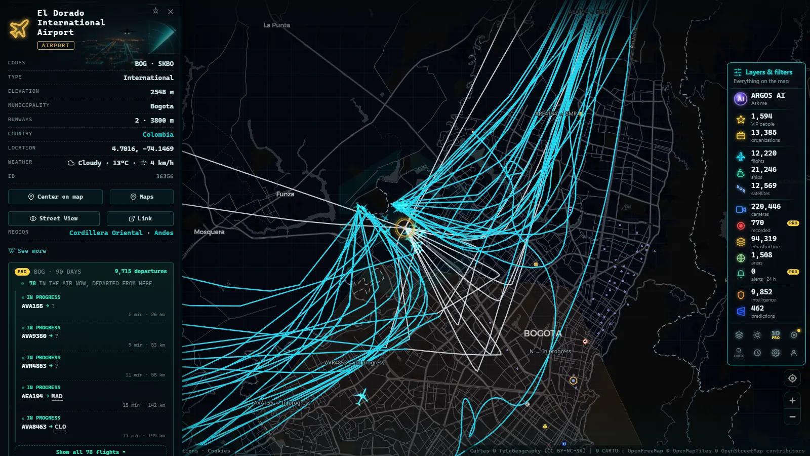
Four civil airports carry most of what there is to watch live over South America: El Dorado in Bogotá, Jorge Chávez in Lima, José Joaquín de Olmedo in Guayaquil and the two fields that serve Buenos Aires. Open the map on any of them and you get the aircraft on approach with callsign, altitude and track, the airport's own card with its ICAO and IATA codes and published tower frequencies, and whatever public cameras happen to exist in the city around it. No account, no payment, no app.
This is not a passenger ranking. The catalogue holds 47,927 airports worldwide, and the point of these four is that they are the ones people actually open: hubs with enough traffic that something is always moving, in a region where radio coverage is patchy enough that what you see needs reading. When this was written the live layer carried 12,387 flights, 4,027 of them on estimated positions rather than fresh reports.
The essentials, in 20 seconds
- El Dorado (SKBO / BOG), Bogotá: the region's heaviest mix of cargo and passenger traffic, with approaches over a high plateau that make the altitude figures read oddly.
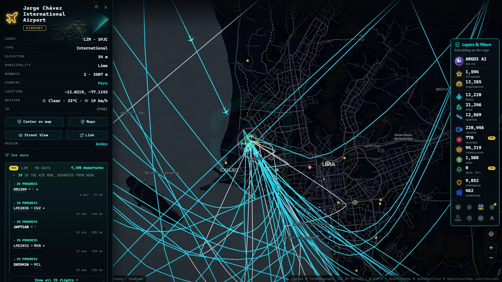
- Jorge Chávez (SPJC / LIM), Lima: sits on the coast beside the port of Callao, so aircraft and ships share one view.
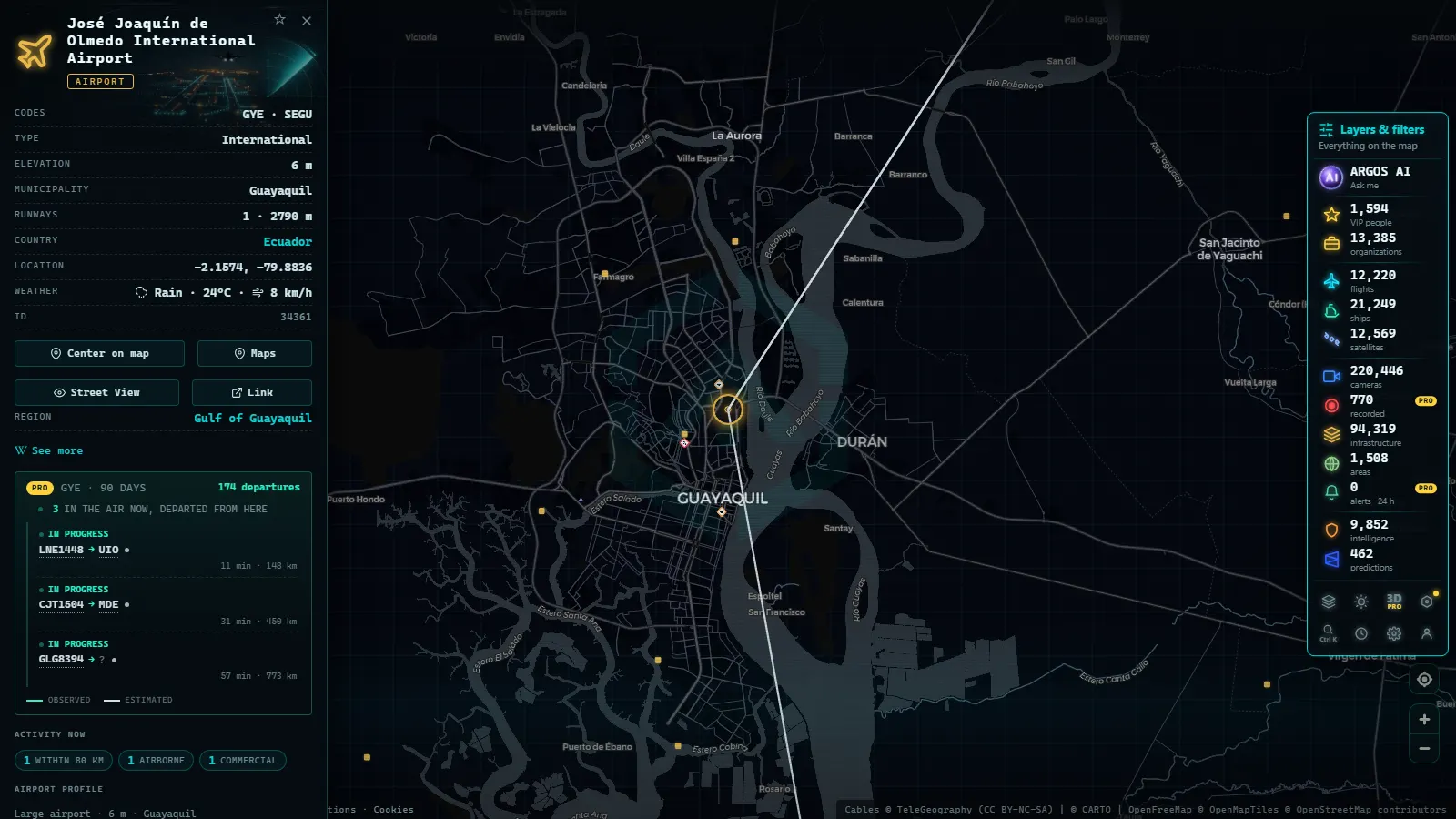
- José Joaquín de Olmedo (SEGU / GYE), Guayaquil: a single runway inside the city, with approaches crossing the río Guayas.
- Buenos Aires has two fields: Aeroparque (AEP) on the Río de la Plata shoreline and Ezeiza (EZE) inland for long haul.
- Live and free: positions refresh in seconds, codes and frequencies come from the airport card, and nothing asks you to register.
What a South America airports live map actually shows
Three layers sit over the same ground and they behave differently. Flights come from ADS-B receivers plus multilateration, which means dense coverage over the coastal cities and thin coverage over the Andes and the Amazon basin: an aircraft can vanish for minutes mid continent and reappear on descent. Airports come from a static catalogue, so the card for a field is there whether or not anything is flying into it. Cameras are public feeds published by traffic authorities and city operators, and in this region they are scarce next to Europe or the United States, where the same catalogue holds 220,446 cameras in total (count as of October 2026).
The practical consequence: around these four hubs you will almost always have aircraft, usually have a card with frequencies, and only sometimes have a camera. Of the flights in the layer, 195 were tagged military, which in South America usually means transport and maritime patrol rather than fast jets.
Bogotá: El Dorado, and where the Colombian detail lives
El Dorado (SKBO / BOG) sits at the high end of the altitude problem: approaches come in over a plateau, so the numbers on an aircraft's card look wrong until you remember how high the ground itself is. Watch the arrivals from the east and they descend to figures that would be cruise-adjacent anywhere near sea level.
Colombia gets its own page rather than a paragraph here, because the interesting part is the set: El Dorado plus Medellín and Cali, with the regional fields that feed them. If Bogotá is what brought you, go straight to the breakdown of Colombia's airports live on the map and come back for the rest of the continent. What belongs here is the comparison: of the four hubs in this article, Bogotá is the one where cargo movements are as visible as passenger ones, and the one whose approach geometry is least like the others.
From the ARGOS ATLAS channel.
Lima: Jorge Chávez and the Callao waterfront
Lima is the best of the four for watching two layers at once. The field sits on the coast beside Callao, so a single view can hold an inbound on final and a bulk carrier waiting offshore. Zoom out slightly and the ship layer fills the anchorage; the vessels sitting still for days are not broken trackers, they are waiting for a berth.
Street level is thinner. No public camera points at the runway, but the city publishes feeds in the districts south of it, which is where the view above comes from: Miraflores, on the cliff, useful for weather rather than for traffic. If you want the road side of the city in detail, the guide to traffic cameras in Lima covers which feeds exist and how often they actually move.
Guayaquil: Olmedo over the río Guayas
SEGU / GYE is the most urban field of the four: one runway, city on both sides, and approaches that cross the río Guayas low enough that the track on the map reads almost like a street. With a single runway the pattern is easy to learn, so ten minutes of watching tells you which end is in use from the direction of the first two arrivals.
The port is the other half of Guayaquil. The container terminals downriver push a steady line of AIS traffic along the estuary, and the pairing is the one Lima offers too: a plane descending while a ship waits. What the map cannot give you here is a camera, on the field or on the river bank, so Guayaquil is flights and ships only.
Buenos Aires: Aeroparque, Ezeiza and the river cameras
Buenos Aires is the only one of the four with a real two field split. Aeroparque (AEP) is wedged between the city and the Río de la Plata, so its arrivals track over water and turn late; Ezeiza (EZE), inland to the south west, takes the long haul and the heavier metal. They are far enough apart on the map that you should pick one and zoom rather than try to hold both.
This is also the only one of the four with usable street cameras near the water:
Martínez looks over the northern suburbs that Aeroparque traffic passes; Dock Sud sits on the industrial side of the harbour, next to the Costanera generating station. For the shipping half of the city, the rundown of Argentina's ports in real time has the berths and the river traffic.
The four hubs side by side
| Airport | City (local name) | Codes | When to look |
|---|---|---|---|
| El Dorado | Bogotá | SKBO / BOG | Early morning and late evening, when cargo stacks up |
| Jorge Chávez | Lima (Callao) | SPJC / LIM | Daytime, for an arrival and the anchorage in one frame |
| José Joaquín de Olmedo | Guayaquil | SEGU / GYE | Any ten minute window, to read the active runway end |
| Aeroparque | Buenos Aires | AEP | Afternoon, for shuttle traffic turning over the river |
| Ezeiza | Buenos Aires | EZE | Night, when the intercontinental departures go out |
Five rows for four cities, because Buenos Aires needs two. The codes column is what you type into the map's search if you would rather not pan: the ICAO code is the unambiguous one, since IATA codes get reused by smaller fields in other countries.
Reading an approach without guessing
A flight card gives callsign, altitude, ground speed, heading and, when the registry has it, type and operator. The two that matter for an approach are the altitude and its trend: a steady descent on a stable heading towards a runway end is an arrival, while a level track at constant altitude straight across the city is an overflight, and plenty of what crosses Lima or Bogotá is neither landing nor departing.
Estimated positions are the trap. When a receiver loses an aircraft the layer keeps it moving on its last known vector, which is why 4,027 of the 12,387 flights were estimated rather than reported. Over the Andes that estimate can be minutes stale, and the track can be a straight line where the real route curved. The general method, including how to tell dead reckoning from a live report, is in the guide to watching aircraft in real time.
ATC frequencies: what the card gives you
The airport card lists published frequencies by role: tower, ground, approach and the information services. That is text, not audio. You get the number and the label, in the language of the page you are reading, whether or not anyone is transmitting. It is enough to know which frequency a tower works on and to pair it with your own receiver, and it is not a scanner.
For these four, the useful part is the approach frequency, because it shows how the airspace is divided: in Buenos Aires that means Aeroparque and Ezeiza worked as one busy block of river and plain, while Guayaquil's single runway needs far less structure. Frequencies change with the official publication cycle, so treat the card as a starting point and not as the current chart.
What you won't see
- No video. Public cameras deliver still frames on a refresh cycle. A frame that looks frozen is between updates, or the operator has dropped it.
- No airfield cameras. None of the four has a public feed pointed at a runway; the nearby city feeds show weather and road conditions, nothing more.
- No people or plates. The frames are low resolution by design and nothing is enhanced: no faces, no number plates, no vehicle identification.
- Night gaps. Unlit urban cameras go effectively dark, and several operators stop publishing overnight.
- Inland coverage holes. Away from the coastal corridors, ADS-B reception is thin, so aircraft drop out, reappear, or coast on an estimate.
- No military detail. The flights tagged military carry a callsign and little else, and nothing about cargo or intent can be read off the map.
Three things to try on the South America airports live map
Open the live map of airports, flights and ships and do these in order. One: search SPJC, zoom until the ship layer appears, and find an arrival and an anchored vessel in the same view. Two: switch to SEGU and watch two arrivals to work out the active runway end, then check the approach frequency on the card. Three: go to Buenos Aires, open the Martínez camera, and compare the sky in the frame with what the flight layer says is passing overhead; when the two disagree, the camera is the older of the two.
The two camera views cited above, Lima and Buenos Aires, on one minimap:
The camera points cited
50 km
Frequently asked questions
Is the South America airports live map free, and do I need an account?
Yes, free and with no registration. The flight layer, the airport cards with their ICAO and IATA codes, the published frequencies and the public cameras all open in a browser with nothing to install and no login. There is no trial period and no paywall on any of the four hubs described here.
Why do aircraft disappear between South American airports?
Because ADS-B coverage is uneven. Receivers cluster around the coastal cities, so an aircraft crossing the Andes or the Amazon can go unreported for minutes. The map keeps it moving on its last known vector, which is why 4,027 of the 12,387 flights in the layer were estimated rather than freshly reported.
Can I listen to tower audio for Lima or Buenos Aires?
No. The airport card lists published frequencies by role (tower, ground, approach) as text, not as audio. You get the number and the label whether or not anyone is transmitting. To hear the exchange you need your own receiver within range or a separate audio service, which the map does not provide.
Are there public cameras pointed at these airports?
No. None of the four has a public feed on the field itself. What exists is city cameras nearby: Miraflores in Lima, Martínez and Dock Sud around Buenos Aires. They are useful for weather and road conditions, and they deliver still frames on a refresh cycle, not video of aircraft.
Which of the four is the best starting point?
Lima, because the airport and the port of Callao fit into one view, so a single zoom level gives you an arrival on final and ships waiting at anchor. Bogotá comes next if cargo interests you, and Buenos Aires if you want two fields plus street cameras in the same city.
- Data centers in Mexico: the 4 cities and what you can check
- Data Centers in South America: Caracas, Lima, Buenos Aires
- Copper mines Chile Peru map: 4 live layers, and the blind spots
- What is critical infrastructure and why does it appear on public maps
- The World's Largest Ports and How to Watch Their Activity Live
- Submarine Cables: The Hidden Map That Holds the Internet Together