Blog · Ships & AIS
Strait of Gibraltar crossing operation 2026: watch it live
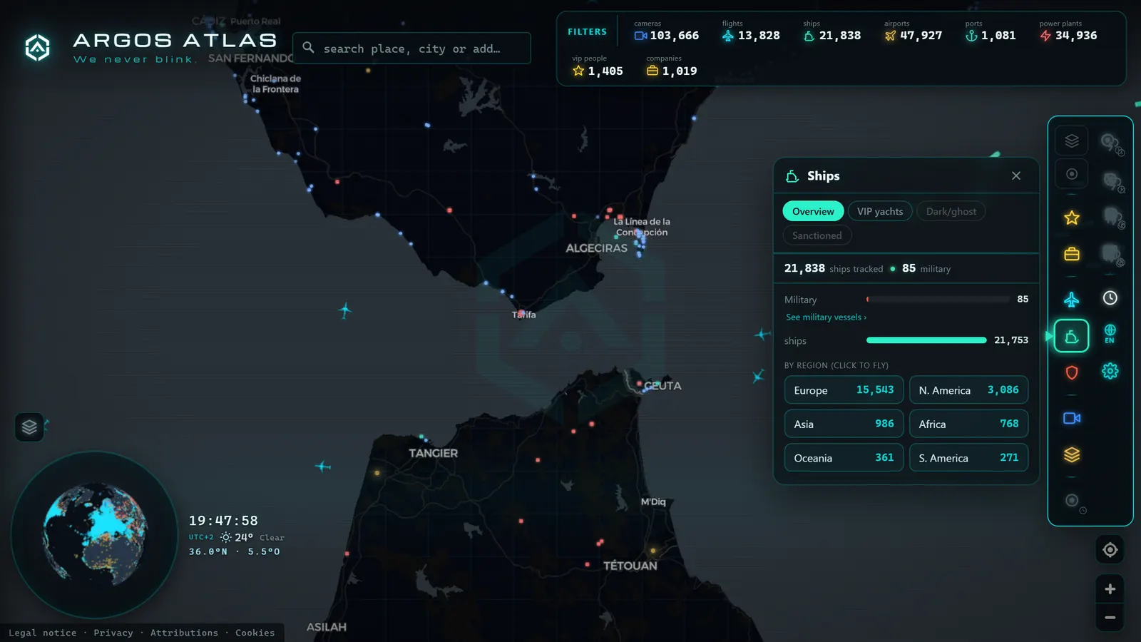
For three months every summer, the fourteen kilometres of water between Spain and Morocco carry what is, by concentration and volume, the largest organised passenger movement in Europe. Hundreds of thousands of people (largely North African families living and working in Europe, heading home for the holidays) cross by ferry, and a joint scheme known in Spanish as the Operación Paso del Estrecho, or OPE, exists so that eight ports do not seize up at once.
The part rarely told is that almost all of it is observable from the outside. Every ferry broadcasts AIS, the road approaches to the ports have public traffic cameras, and both layers can be read side by side. This guide covers the 2026 calendar, how to follow the operation live, and (as always here) which parts no open-data map can show you.
What the operation is, and why it exists
The Strait of Gibraltar crossing operation is not an event. It is an annual coordination scheme that brings together Spanish and Moroccan authorities, port operators, ferry companies, traffic police, health services and emergency teams around a single problem: absorbing in three months a flow of passengers and vehicles that any other time of year would spread across many more.
The sea is not the bottleneck. Fourteen kilometres take very little time and there is plenty of tonnage. The pinch points are on land: parking thousands of heavily loaded cars, clearing border controls in two countries, and loading and unloading without turning a quay into a plug. That is why the operation is run like a logistics exercise, with holding areas, staffing surges and ferry capacity adjusted week by week.
All of it happens on top of a shipping lane that is already one of the busiest on the planet, with Atlantic–Mediterranean merchant traffic running perpendicular to the ferries. Our guide to Ceuta and the Strait live covers that underlying geography; this one is about the human layer laid over it each August.
The 2026 calendar: phases and peaks
The 2026 scheme runs from 15 June to 15 September. Within those dates the traffic is anything but uniform: it comes in two waves pointing in opposite directions.
| Phase | When | What shows up in the data |
|---|---|---|
| Scheme opens | From 15 June | Reinforcements in place and the first extra rotations; traffic still moderate |
| Outbound wave | Middle weeks of summer | Europe → North Africa dominates; the Algeciras approaches load up in the mornings |
| Return wave | Second half of August | The dominant direction flips; pressure shifts to the African ports and to European arrivals |
| Return peaks | Weekends of 28–31 August | The busiest stretch forecast for the whole operation |
| Wind-down | Through to 15 September | A gradual decline back to the Strait's normal commercial rhythm |
What that means in practice: during the outbound wave, watch the European quays and the motorway. During the return, watch the vessels coming up from the southern shore and the arrivals. Same stage, two different films.
The eight ports involved
The operation is spread across eight ports with very different roles. Knowing them saves time once the map is open.
| Port | Shore | Role in the operation |
|---|---|---|
| Algeciras | Mainland Spain | The main hub: links to Ceuta and Tanger Med, layered on a commercial port that never stops |
| Tarifa | Mainland Spain | The shortest, fastest hop, to Tangier Ville; highly exposed to the levante wind |
| Ceuta | North Africa (Spain) | The Spanish gateway on the African shore, with short continuous rotations to Algeciras |
| Melilla | North Africa (Spain) | Links to south-eastern mainland ports; a slower rhythm and longer crossings |
| Tanger Med | Morocco | A large modern terminal outside the city, built to absorb volume |
| Tangier Ville | Morocco | The in-town passenger terminal, the far end of the Tarifa hop |
| Motril | Mainland Spain | An eastern alternative that relieves pressure on the Bay of Algeciras |
| Almería | Mainland Spain | Routes to Melilla and eastern Morocco, with crossings of several hours |
They do not all behave alike. Algeciras and Tarifa carry the visible pulse of the operation; Motril and Almería act as relief valves; Melilla runs to its own longer, less concentrated calendar.
From the ARGOS ATLAS channel.
How to follow the Strait of Gibraltar crossing operation live
Here is the part no press release gives you: the whole thing can be watched in real time with two layers switched on together in the ARGOS ATLAS map.
The ship layer (AIS) does the heavy lifting. Every commercial vessel transmits identity, position, course and speed, and ferries are no exception. With the layer on over the Strait you see rotations as they actually happen, not as they were scheduled. If the system is new to you, our explainer on what AIS is takes five minutes, and how to follow a ship live shows you how to lock onto one vessel and keep it.
The camera layer covers the other half of the journey. Across the Strait as a whole there are around forty public cameras (count on the map as of August 2026), spread between Tarifa, Algeciras, the bay and the Gibraltar area. None of them are berth or boarding-gate cameras. They are traffic, port and beach cameras, good for the road approach and for reading sea state and wind, which at Tarifa decide more crossings than most people realise.
Reading the Algeciras–Ceuta and Tarifa–Tangier ferries minute by minute
A short-haul ferry draws an unmistakable pattern on a map: out, back, out, back, with pauses at each end. Learning to read that pattern is what turns a screen of dots into something useful.
- Zero speed alongside a quay: the ship is loading or discharging. The longer that pause runs compared with the day's norm, the more loaded the terminal is.
- High speed on a steady course: crossing in progress. On the Algeciras–Ceuta run you will watch it clear the bay and settle; on the Tarifa–Tangier ferry, cut almost perpendicular to the merchant flow through the traffic separation scheme.
- Low speed outside the port: waiting for a berth. This is the single most telling sign of congestion, the ship and the passengers are there, the quay is not free yet.
- Several units overlapping on the same route: extra capacity deployed, typical of the heavy days.
If you want the Algeciras–Ceuta ferry today, the workflow that works is: centre the map on the bay, switch on ships, find the vessels doing short repeated hops, and look at which one has just departed. That tells you the true state of the rotation long before any departures board does.
Algeciras traffic during the operation: the road approaches
The other half of the trip happens on tarmac. The A-7 motorway and the approaches to Algeciras and Tarifa are the funnel everyone crossing by car passes through, and that is where public cameras earn their keep. Spain has roughly 10,900 public traffic camera points on the map (count as of August 2026), and how that network is organised is covered in our guide to traffic cameras in Spain.
For Algeciras port traffic during the operation, check three things in this order: the approach corridor from Málaga and Cádiz, the last few kilometres before the port area, and (if you are heading for Tarifa) the coastal N-340. How often these cameras refresh and what can fairly be inferred from them is detailed in our complete guide to Spain's DGT cameras.
A peak day versus an ordinary day
The best way to understand the operation is to compare. Open the same area on an ordinary Tuesday in August, then on a weekend at the end of the month, and watch these signals.
| Signal | Ordinary summer day | Return-wave peak day |
|---|---|---|
| Ferry rotations | Spaced out, with clear gaps between crossings | Overlapping, with departures chained in both directions |
| Time alongside | Short and regular | Longer, with vessels holding outside the port |
| Road approaches | Free-flowing outside local rush hour | Dense from early morning, stacking in the final kilometres |
| Merchant traffic | Orderly east–west flow along the lanes | The same flow, crossed by far more north–south tracks |
| Bay anchorage | Normal occupancy | Equal or higher: trade does not pause for the operation |
That last line surprises people. The operation does not replace the Strait's commercial traffic; it is added on top of it. What you see on a peak return day is a marine motorway running in two perpendicular directions at once.
Practical advice if you are crossing
- Look at the actual ship before you leave home. Knowing whether your ferry is alongside, crossing or waiting for a berth changes what time you should get in the car.
- Allow a generous margin. On the heavy days, the time is lost on the approach, at the controls and at boarding, not at sea.
- Check the wind if you are going via Tarifa. The levante is the most common cause of disruption on the short hop, and the local webcams give it away before any bulletin does.
- Have a geographical plan B. If your route allows Motril or Almería, a quick look at how those ports are breathing can save you half a day.
- Do not mistake activity for availability. Lots of ferries moving means capacity is deployed, not that there is space on the next sailing.
What the map will not tell you
Now the uncomfortable part, which is also the most useful. The map shows traffic, not service. Specifically, you will not see:
- Official timetables or operator-announced delays.
- Boarding waiting times, foot-passenger queues or holding-area occupancy.
- The situation at the border controls, which have no public cameras.
- Ticket or vehicle-space availability.
All of that comes from the ferry operators, the port authorities and the bodies that run the scheme. What open data adds is the context those sources do not publish in real time: exactly where the ship is, how the road approach looks, and whether today resembles the forecast or not.
That is enough to make better decisions. Open the map, centre it between Tarifa and Ceuta, switch on ships and cameras, and give the corridor two minutes before you pick up the keys. In an OPE summer, those two minutes beat any forecast.
Frequently asked questions
What are the dates of the 2026 Strait of Gibraltar crossing operation?
The scheme runs from 15 June to 15 September 2026. The outbound wave fills the first half of that window and the return wave the second, with the busiest days forecast for the final weekends of August, between the 28th and the 31st.
Can I track the Algeciras–Ceuta ferry in real time?
Yes. Strait ferries are commercial vessels and broadcast AIS, so their position, course and speed appear on the map while they sail. You will see whether a crossing is under way, whether the ship is alongside or whether it is inbound, though not the official timetable.
Which ports take part in the operation?
On the European shore, Algeciras, Tarifa, Motril and Almería. On the African side, the Spanish cities of Ceuta and Melilla plus the Moroccan ports of Tanger Med and Tangier Ville. Algeciras is the main hub and Tarifa the shortest hop.
Is it free to follow the operation on the map, and do I need an account?
It is free and no account is required. The AIS ship layer and the public camera layer are both open, with no paywall and no query limit for watching the Strait live.
Does the map show how long the boarding queue is?
No, and that matters. The map shows where each vessel is and how the road approaches look on public traffic cameras, but not boarding times, foot-passenger queues or space availability. Those come from the ferry operators and the port authorities.
- MarineTraffic alternatives: what free AIS tracking really does
- Pescara Port Live: 6 Ship Types on the Adriatic AIS
- Malta ship traffic live: what crosses between Sicily and Africa
- Panama Canal Ship Traffic Live: Read Both Queues on the Map
- Argentina Ports Live: Buenos Aires, Rosario, Bahía Blanca
- How to track a ship in real time: name, MMSI, and IMO explained