Blog · Ships & AIS
How to track a ship in real time: name, MMSI, and IMO explained
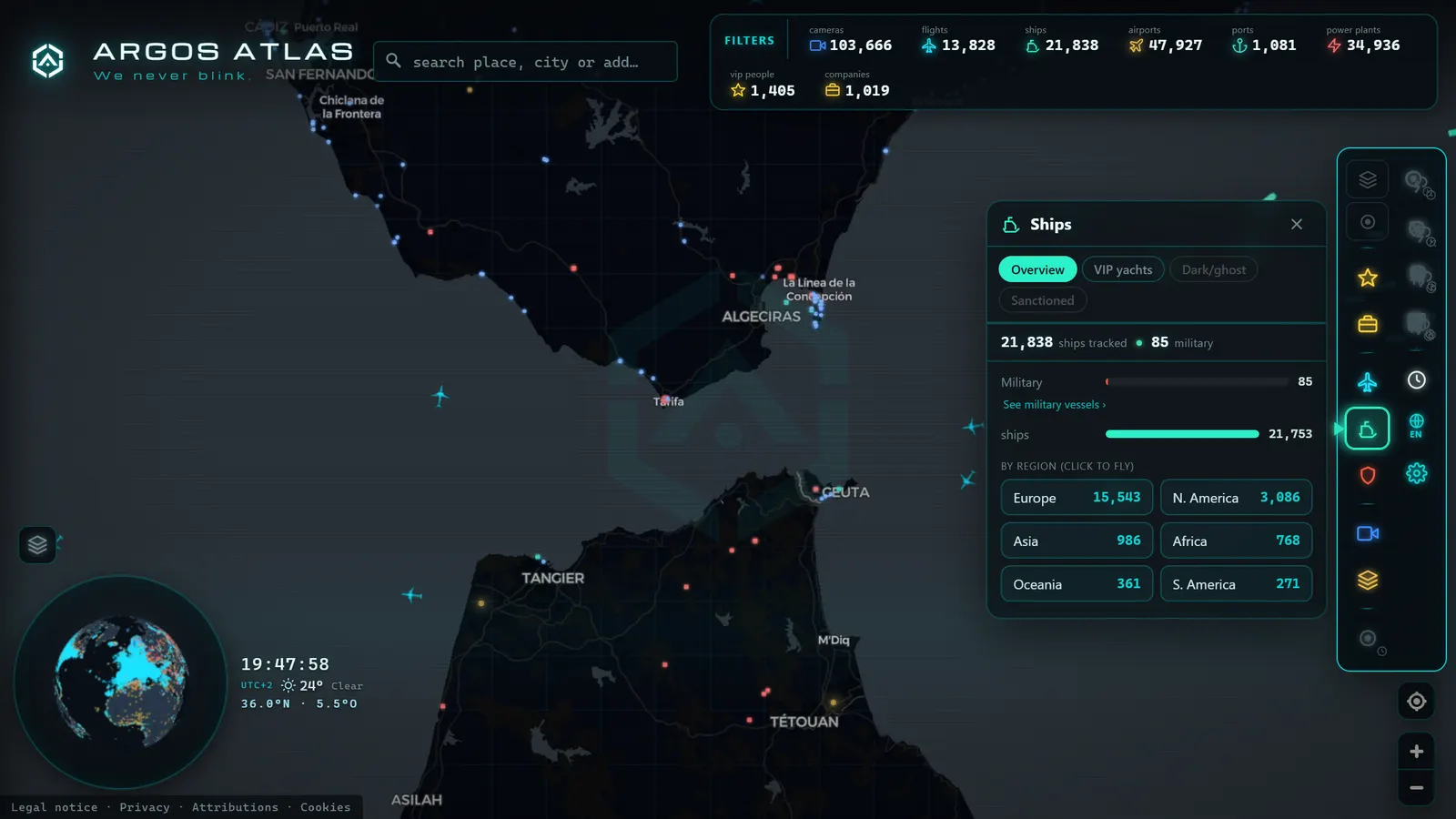
Your family is sailing back from a cruise and you want to know exactly where the ship is. Or a news story mentions a freighter stranded outside a major port and you want to see it on the map for yourself. Tracking a ship in real time is now as straightforward as looking up an address, but there is a small art to doing it well: vessel names are deceptive, data cards carry fine print, and it pays to know which identifiers are actually reliable. This guide shows you how to locate any vessel and read its information with confidence, without falling into the most common traps.
The essentials, in 20 seconds
- MMSI: nine digits broadcast in every AIS message, but it changes if the vessel re-flags to a new country.
- IMO number: seven digits assigned at construction that never change, making it the only identifier that survives name and owner changes.
- Dynamic data (position, course, speed): comes straight from the ship's instruments, the most trustworthy field on any data card.
- Destination and ETA: free-text fields typed manually by the crew, so typos, abbreviations, and stale entries are common and not suspicious.
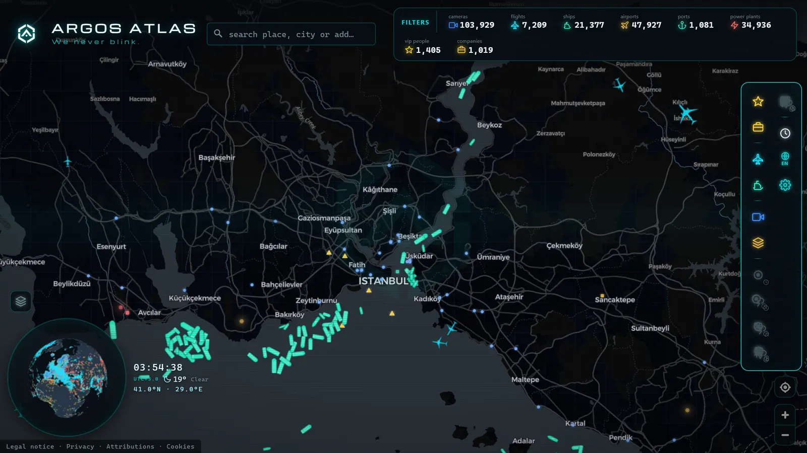
- Argos Atlas: shows live ships by category and speed on a world map that also includes ports and public traffic cameras nearby.
The problem with names: why searching by name alone is not enough
Start with the most common beginner mistake: searching for a ship by name and accepting the first result. The sea is full of namesakes. Vessel names repeat constantly across saints, cities, and geographic features that appear on dozens of hulls, and nothing prevents two entirely different ships from sailing simultaneously under the same name and different flags.
There is a second problem: names change. When a vessel is sold, the new owner typically renames it; a single hull can accumulate half a dozen names over its lifetime. The cruise ship your family sailed on a decade ago may well be trading today under a different name, livery, and company.
The practical consequence: the name is useful for starting a search, but never for confirming one. That is what the serious identifiers are for.
The serious identifiers: MMSI and IMO
Just as an aircraft has a registration and a transponder code, a vessel has two identifiers that truly matter.
The MMSI: nine digits tied to the radio
The MMSI (Maritime Mobile Service Identity) is a nine-digit number that identifies the vessel radio station. It is the identifier broadcast in every AIS message, which means it is what receiver networks use to distinguish one ship from another in real time.
Its opening digits function as a country prefix, indicating the flag state under which the radio station is registered. Here is the important nuance: the MMSI can change. If a vessel re-flags, common practice in shipping, it receives a new MMSI from its new flag state. It is an excellent identifier for day-to-day tracking, but not for following the complete biography of a hull.
The IMO: the number that stays with the hull forever
For that purpose there is the IMO number: seven digits assigned to the vessel that remain with it from construction to scrapping, never changing, regardless of how many names, owners, and flags accumulate. The system was introduced by the International Maritime Organization precisely so that no commercial identity change can erase a hull history.
The name is the costume, the MMSI is the current identity document, and the IMO is the fingerprint: the one thing a vessel cannot change.
When investigative journalists report on vessels with murky histories that cycle through names and flags, they always pursue the ship by its IMO number. The same logic applies at a smaller scale: if you want to be certain which vessel you are looking at, find the IMO.
From the ARGOS ATLAS channel.
How to track a vessel, step by step
With those identifiers in mind, the process is straightforward. Here is how to do it properly.
- Search by name on a live maritime map. If you already know the MMSI or IMO, search by that directly and skip the namesake problem entirely.
- Confirm the identity. If a name search returns multiple results, compare: does the vessel type match (cruise ship, container ship, ferry)? Do the dimensions fit? Is the flag what you expected? Does the MMSI or IMO align with what you have? Do not proceed until you are confident this is the right ship.
- Place it on the map and read its dynamic data: current position, course, speed, and navigational status. A vessel underway at cruising speed tells one story; one sitting at anchor off a port tells quite another. If you encounter that second case, the article on what it means for a ship to be at anchor explains the distinction clearly.
- Check the voyage data: declared destination and estimated time of arrival, with the caveats covered in the next section.
- Return whenever you like. That is the value of live tracking: the position will have moved, and with the map context -- ports, coastline, surrounding traffic -- you can read the vessel progress at a glance.
All of this is powered by the AIS system carried aboard every qualifying vessel. If you want to understand exactly where these data come from and why they are publicly accessible, the article on what AIS is and how ships are tracked is the right starting point.
Reading the data card critically: the fine print
This is where informed observers part ways from naive ones. Not every field in a vessel data card carries the same reliability, and it helps to know which is which.
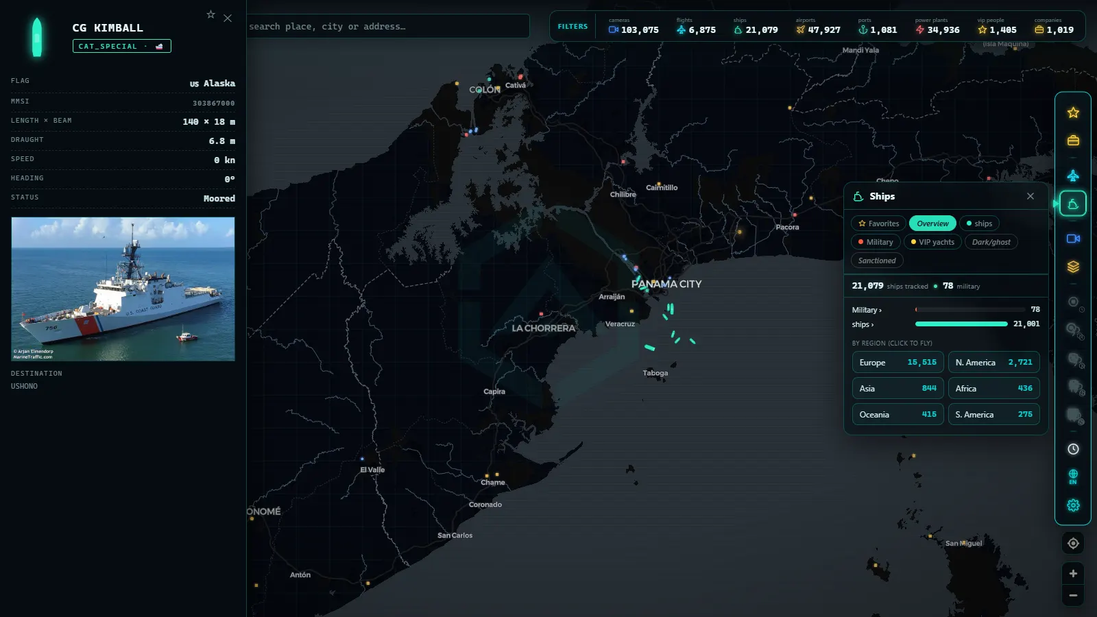
Dynamic data -- position, course, speed -- are the most trustworthy: they come directly from the ship instruments and are transmitted automatically. If the map shows a vessel heading north at 18 knots, that is what is happening, subject only to the refresh lag of a given data source.
The destination, by contrast, is a different matter entirely: it is a free-text field entered manually by the crew. That means abbreviations understood only by insiders, port codes instead of names, typos, idiosyncratic formats, and the classic stale destination left over from a previous voyage because no one remembered to update it. Seeing an odd or inconsistent destination does not suggest anything suspicious; it simply means a human typed that field.
The ETA (estimated time of arrival) carries the same character: it is an estimate entered by the crew, and it can become outdated if a voyage is delayed or rerouted. The navigational status is also selected manually, which is why you occasionally see vessels clearly underway displayed as moored because the selector was never updated.
The working rule: trust what the ship measures automatically; treat what the ship declares as a rough guide.
Use cases: what live ship tracking looks like in practice
Tracking vessels is not the exclusive domain of maritime professionals. These are the most common uses among the general public.
- Waiting for a cruise to arrive. You have family on board and want to know whether they will make port on time: locate the vessel, observe its position and speed, and form a far better estimate than any typed ETA.
- Following the ship in the news. Periodically a vessel commands headlines -- a container ship aground in a major waterway, a bulk carrier waiting weeks outside a congested port -- and seeing it on the map transforms an abstract news story into something tangible. Think of the Ever Given in the Suez Canal, or the vessels that backed up outside Shanghai during port closures.
- Watching the ferries on your local coast. If you live near the water, the regular ferry services and coastal traffic become a small daily spectacle: you learn schedules, recognize routes, and begin to identify individual ships by their data cards.
- Pure curiosity. Pick any point in the ocean, see what is passing through, and wonder what it carries, where it came from, and where it is going. To put names to what you see, it helps to know the types of merchant vessels and their characteristic silhouettes.
Seeing it on a map with context
An isolated vessel icon on a blank screen says little; a vessel overlaid on a contextual map says almost everything. In Argos Atlas, live ships are displayed by category and with their speed, on a world map that also includes ports and public traffic cameras in the vicinity, alongside other data layers. That context transforms the reading: you see the vessel you are following, but also the port it is approaching, the traffic surrounding it, and the geography that explains its route.
Because everything lives in a single map, you can jump from your vessel to the flights passing overhead or to coastal activity without switching tools. Maritime curiosity rarely travels alone.
The limits of live tracking: managing expectations
To close with honesty about what live ship tracking can and cannot deliver:
- Update frequency depends on the source and the area. Close to shore, with land-based AIS antennas in range, positions refresh almost continuously. In open ocean, where satellite passes govern coverage, the most recent data point may carry significant lag. A vessel that appears stationary in the middle of the Pacific is almost certainly still underway -- there is simply no recent update.
- Not all ships transmit at all times. Equipment switched off, technical faults, or crew decisions mean some vessels disappear temporarily from open-access networks.
- Declared data is declared. As discussed, destination and ETA depend on human input.
None of this diminishes the experience; knowing it makes you a better observer. The ocean is vast, reception networks do what they can, and what ultimately reaches your screen is remarkable.
Frequently asked questions
How do I find a ship by name?
Search on a live maritime map and review the results carefully, because vessel names repeat frequently. Confirm you have the right ship by comparing vessel type, dimensions, and flag against what you know, and if you have the MMSI or IMO, use those as final verification. Bear in mind that ships are renamed when they change hands: if a vessel does not appear, it may be sailing today under a different name.
What is a ship MMSI?
It is the nine-digit number that identifies the vessel radio station and is broadcast in every AIS message, making it the identifier by which receiver networks recognize the ship in real time. Its opening digits indicate the flag state. Note that the MMSI can change: if the vessel re-flags, it receives a new MMSI.
Are MMSI and IMO the same thing?
No. The MMSI identifies the radio station and is tied to the current flag, so it can change over a vessel life. The IMO number, seven digits, identifies the hull from construction to scrapping without ever changing, regardless of name, operator, or flag. The MMSI is the right identifier for day-to-day tracking; the IMO is the reference for a vessel complete biography.
Why does the destination shown on the map sometimes not match the actual voyage?
Because the AIS destination is not an automatic data point: it is a free-text field entered manually by the crew. It can contain trade abbreviations, port codes instead of names, typos, or be left over from a previous voyage. The ETA is equally an estimate entered by hand. Treat both as directional indicators and rely more heavily on what the ship measures automatically: position, course, and speed.
Conclusion
Tracking a ship in real time is easy; doing it well is a matter of method. Start with the name, confirm with the MMSI or IMO, read the dynamic data with confidence, and treat the declared data with healthy skepticism. With those four principles, any vessel in the world -- the cruise ship carrying your family, the freighter making headlines, the ferry crossing your local bay -- is a couple of searches away.
Put it into practice now: open the map in Argos Atlas, search for a vessel that interests you, and check its course, speed, and surrounding context. And if along the way you encounter a ship sitting stationary off a port, you already know where to read about what it means for a vessel to be at anchor.
Frequently asked questions
How do I find a ship by name?
Search for the name on a live maritime map and review the results carefully: there may be several vessels sharing the same name. Confirm you have the right one by comparing vessel type, dimensions, flag, and above all the MMSI or IMO number if you have them.
What is a ship MMSI?
It is the nine-digit number that identifies the vessel radio station. Its first digits indicate the flag state. It is the identifier broadcast in every AIS message, though it can change if the ship re-flags.
Are MMSI and IMO the same thing?
No. The MMSI identifies the radio station and can change with the flag; the IMO number, seven digits, identifies the hull and stays with the vessel for its entire life, regardless of name, owner, or flag changes. For long-term tracking, the IMO is the definitive reference.
Why does the destination shown on the map sometimes not match the actual voyage?
Because the AIS destination is a free-text field entered manually by the crew: it can contain abbreviations, typos, or be left over from the previous voyage. The ETA is likewise an estimate. Treat both as rough indicators, not guaranteed data.
- Dark Vessels: Why Some Ships Turn Off Their AIS Transponder
- Straits and Canals: The Chokepoints of World Trade
- Live Ships in the Caribbean Sea: Cruise Liners, Container Ships and Island Traffic
- Live Ships in the South Pacific: Routes Connecting Chile, Peru and Ecuador to Asia
- Live Ships in the Mediterranean Sea: Ferries, Cruise Liners and Container Ships
- Live Ships in the Strait of Malacca, the World's Busiest Shipping Lane